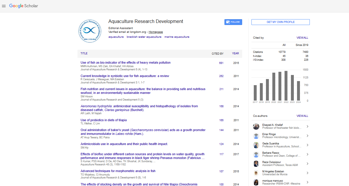
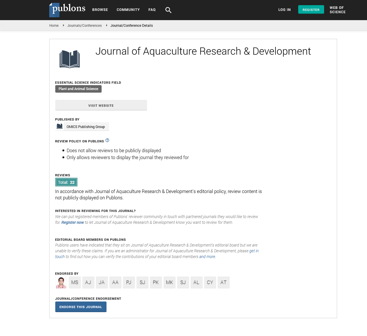

Indexed In
- Online Access to Research in the Environment (OARE)
- Open J Gate
- Genamics JournalSeek
- JournalTOCs
- Scimago
- Ulrich's Periodicals Directory
- Access to Global Online Research in Agriculture (AGORA)
- Electronic Journals Library
- Centre for Agriculture and Biosciences International (CABI)
- RefSeek
- Directory of Research Journal Indexing (DRJI)
- Hamdard University
- EBSCO A-Z
- OCLC- WorldCat
- Scholarsteer
- SWB online catalog
- Virtual Library of Biology (vifabio)
- Publons
- MIAR
- University Grants Commission
- Euro Pub
- Google Scholar
Useful Links
Share This Page
Journal Flyer
Open Access Journals
- Agri and Aquaculture
- Biochemistry
- Bioinformatics & Systems Biology
- Business & Management
- Chemistry
- Clinical Sciences
- Engineering
- Food & Nutrition
- General Science
- Genetics & Molecular Biology
- Immunology & Microbiology
- Medical Sciences
- Neuroscience & Psychology
- Nursing & Health Care
- Pharmaceutical Sciences
Commentary - (2023) Volume 14, Issue 2
Floating Raft Aquaculture Images from Hyperspectral Remote Sensing Technique
Wang Rongguo*Received: 27-Jan-2023, Manuscript No. JARD-23-19946; Editor assigned: 30-Jan-2023, Pre QC No. JARD-23-19946 (PQ); Reviewed: 17-Feb-2023, QC No. JARD-23-19946; Revised: 24-Feb-2023, Manuscript No. JARD-23-19946 (R); Published: 02-Mar-2023, DOI: 10.35248/2155-9546.23.14.727
Description
Scientific management and sustainable growth of coastal zones depend on the precise extraction and mapping of Floating Raft Aquaculture (FRA). The existing pertinent methods, however, rely on massive sample sizes and intricate classifiers, which have limited generalization capacity and are not appropriate for widespread application. This work suggests a novel hyperspectral index based on remote sensing photos to address these problems, called the Hyperspectral Index for Floating Raft Aquaculture (HSI-FRA) Based on the analysis of the spectral data, the HSIFRA employs four bands, one at 580 nm and the other at 740 nm, to increase the spectral difference between the saltwater and the floating raft aquaculture through band computation and create the extraction index of the floating raft aquaculture. The extraction of floating raft aquaculture information is realized using a decision tree classification process using the HSI-FRA, which has greater advantages than those of older approaches. The experimental findings indicate that the suggested method is effective at separating the floating raft aquacultures in an offshore complicated maritime environment because it is straightforward, quick, and precise.
A production method known as offshore aquaculture uses artificial means to encourage the breeding, reproduction, and growth of marine creatures and plants. An important form of offshore aquaculture known as Floating Raft Aquaculture (FRA) often takes place in shallow oceans with a depth of 10 to 20 meters. The Food and Agriculture Organization (FAO) estimates that the peak year for world fish output was 2016, when 171 million tons were produced, with 47% coming from aquaculture (FAO, 2016). Tropical, subtropical, and temperate monsoon climate zones are represented in China's coastal zones, which extend from the mouth of the Yalu River in the north to the estuary of the Beilun River in the south. These climate zones offer ideal innate conditions for the development of offshore aquacultures. China, which produces more than 60% of the world's aquaculture products, is a key player in addressing concerns related to global food security and nutrition. However, the recent rapid growth of aquaculture areas has brought about a number of difficulties, including the depletion of biodiversity, the shrinkage of natural wetlands, and contamination of the maritime environment. Therefore, precise offshore floating raft aquaculture monitoring is crucial for the management of coastal zones on a scientific basis and for the sustainable growth of coastal areas.
Field measurements and statistical surveys are typically used to extract information for FRA. The field measurement approach is time- and money-consuming, while statistical survey methods' findings are highly unclear and subject to human error. With its broad spatial coverage, quick imaging speed, several spectral bands, and lengthy time series, remote sensing technology has taken over as the primary method for gathering data from FRA regions. To automatically recognize and extract offshore floating raft aquaculture information, various techniques have been developed recently. Currently, pixel-based classification, objectoriented classification, and deep learning-based approaches are the three main ways to complete this task. In order to distinguish the spectral information differences between the FRA and other ground objects, the pixel-based classification method is used. Threshold segmentation, supervised classification, and spectral indices are the major components of this method. It is a simple and quick procedure, but it needs to be applied in a way that distinguishes between diverse things' spectral characteristics because it might be impacted by claims like "the same object has different spectra" and "different objects have the same spectrum."
The object-oriented categorization approach uses rules for object characteristics including spectrum, shape, and texture to identify and extract the FRA information. Although this approach is very accurate, it is also time-consuming to set up the rules. To extract the information about offshore floating raft aquaculture, the deep learning-based method is integrated with fully convolutional neural network, stacking sparse auto-encoder, and other algorithms. Deep learning methods have shown comparable results with excellent recognition accuracy, but they require a huge number of training examples for various contexts. Multispectral remote sensing data with medium and high spatial resolution are the most popular data sources utilized in current research. In actuality, multispectral images have a broad range, few bands, and weak recognition abilities. The special spectral properties of offshore FRA cannot be completely utilized for complex marine environments like nearshore turbid water bodies. Low extraction precision is caused by the phenomenon of "same object has distinct spectra" and "different things have the same spectrum. Index construction is driven by the aforementioned limitations and offers clear benefits like wideranging applications and simple, quick, and strong generalization. Using more than 100 small bands, hyperspectral imaging gathers continuous spectral responses from visible to shortwave infrared wavelengths. It offers data opportunities for extensive monitoring and has better capacity for differentiating ground items.
Citation: Rongguo W (2023) Floating Raft Aquaculture Images from Hyperspectral Remote Sensing Technique. J Aquac Res Dev.14:727.
Copyright: ©2023 Rongguo W. This is an open access article distributed under the terms of the Creative Commons Attribution License, which permits unrestricted use, distribution, and reproduction in any medium, provided the original author and source are credited