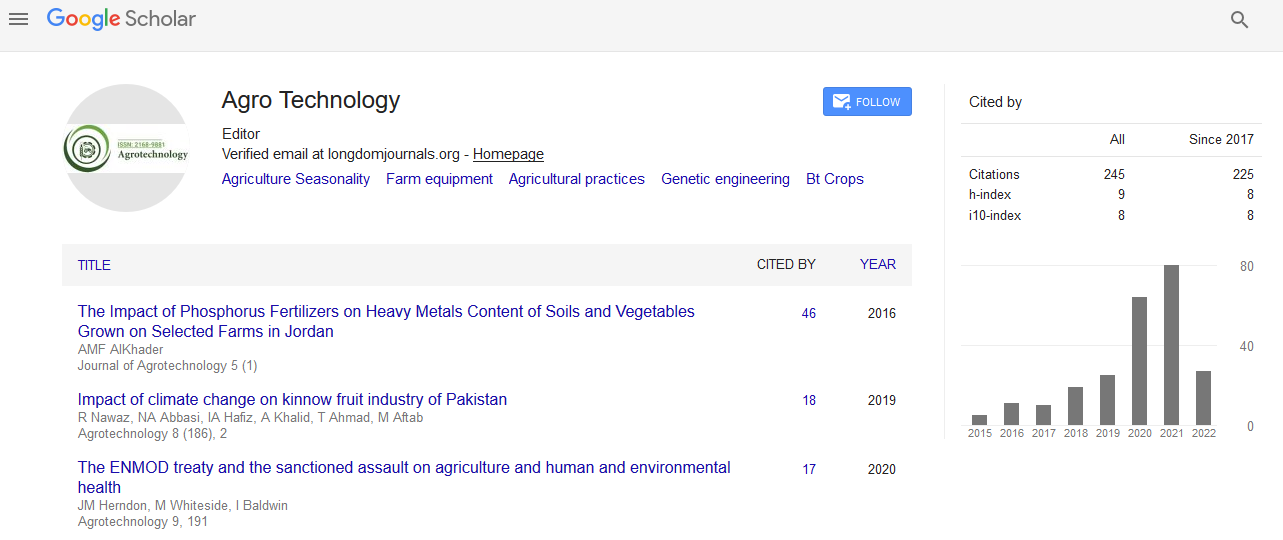

Indexed In
- Open J Gate
- Genamics JournalSeek
- Academic Keys
- ResearchBible
- Cosmos IF
- Access to Global Online Research in Agriculture (AGORA)
- Electronic Journals Library
- RefSeek
- Directory of Research Journal Indexing (DRJI)
- Hamdard University
- EBSCO A-Z
- OCLC- WorldCat
- Scholarsteer
- SWB online catalog
- Virtual Library of Biology (vifabio)
- Publons
- Geneva Foundation for Medical Education and Research
- Euro Pub
- Google Scholar
Useful Links
Share This Page
Journal Flyer

Open Access Journals
- Agri and Aquaculture
- Biochemistry
- Bioinformatics & Systems Biology
- Business & Management
- Chemistry
- Clinical Sciences
- Engineering
- Food & Nutrition
- General Science
- Genetics & Molecular Biology
- Immunology & Microbiology
- Medical Sciences
- Neuroscience & Psychology
- Nursing & Health Care
- Pharmaceutical Sciences
Research Article - (2023) Volume 12, Issue 3
Methodology: The Decision Support System for Agrotechnology Transfer (DSSAT) Software Crop Model for Agriculture Decision
Zechariah Jeremaiho1,2,3*, Abdul-Ganiyu Shaibu1,2, Abdul-Halim Abubakari1,4 and Muna Mohamed Elhag52Department of Agricultural Engineering, University for Development Studies, Tamale, Ghana
3Department of Agricultural Engineering, Upper Nile University, Malakal, South Sudan
4Department of Horticulture, University for Development Studies, Tamale, Ghana
5Water Management and Irrigation Institute (WMII), University of Gezira, Wad Maddeni, Sudan
Received: 23-Mar-2023, Manuscript No. AGT-23-20235; Editor assigned: 27-Mar-2023, Pre QC No. AGT-23-20235 (PQ); Reviewed: 10-Apr-2023, QC No. AGT-23-20235; Revised: 17-Apr-2023, Manuscript No. AGT-23-20235 (R); Published: 24-Apr-2023, DOI: 10.35248/2168-9881.23.12.327
Abstract
Decision support system for agriculture was developed with powerful crop models that could allow the researchers to predict crop yield, and impact of environmental challenges on food security, because research in the open field with traditional agriculture alone can’t address issue of food security in developing countries. The DSSAT has been in used by more than 25,000 researchers, educators, consultants, extension agents, growers, and policy and decision makers in over 183 countries. In this paper, we have presented the DSSAT software crop model for agriculture decision. After running the model user will able to estimate the crop response and estimate crop yield. The DSSAT can play a major role in helping to understand the interaction between (Genotype, Environment, and Management), and to provide alternative management options that increase crop yield and quality, optimize resource use, and minimize environmental impact for long-term sustainable agricultural production.
Keywords
WeatherMan; SBuild; XBliud; fileX
Introduction
DSSAT grew out of the International Benchmark Sites Network for Agrotechnological Transfer (IBSNAT) in the 1980s, with the first official release in 1989, introduced a more modular structure and, added tools for agricultural economic analysis and risk assessment. The development has continued in affiliation with the International Consortium for Agricultural Systems Applications (ICASA). The functionality of DSSAT has also been extended through interfaces with other software such as GIS (Geographic Information System). DSSAT typically requires input parameters related to soil condition, weather, and management practices such as fertilizer use, irrigation, and characteristics of the crop variety being grown. The systems analysis approach of the IBSNAT Project was based on biophysical models that predict crop growth, development, and yield using daily weather data, local soil conditions, crop management, and genetics as input [1].
The early versions of these crop models were based on non-uniform and nonstandard input and output files, making it challenging for users to apply models for different crops to the same farming system. Therefore, the Minimum Data Set (MDS) system was developed to standardize the inputs required for these crop models as well as the file formats used [2]. This standardization facilitated the development of data utility programs for processing weather, soil, management input data, and experimental observation files, as well as tools for application and display of output data for the models, forming the basis for the Decision Support System for Agrotechnology Transfer (DSSAT) software [3].
The DSSAT Shell program provides a user-friendly working environment in which various stand-alone tools and applications are seamlessly integrated with the DSSAT crop models. Within the shell, the user can launch applications for creating and modifying data files, running the crop models, and analyzing the results [4]. However, the DSSAT Shell and other applications of the DSSAT system, which are installed separately, were built using technologies under end-of-life support such Visual Basic. Another point is that the DSSAT tools, including the Shell, are available for Windows OS only, which requires users from Linux and MacOS to deal with the command line to run model in DSSAT-CSM. This approach requires a very good understanding of DSSAT-CSM (Decision Support System for Agrotechnology Transfer-cropping system model) commands that might be painful for some users.
PyDSSAT tool, python library to execute original FORTRAN program on Linux, were built to improve DSSAT’s users experience over the terminal command line execution in Linux OS, including the ability of controlling input files, analyzing output files with Matplotlib tools, and providing a GUI toolkit for efficient interactive work integrate with DSSAT-CSM. pyDSSAT is a package that was developed to facilitate the use of DSSAT-CSM within a Python workflow [5]. The package provides command line interface and GUI tools for manipulating simulation batch files and crop management input files, running DSSAT-CSM simulations and analyzing model outputs.
Within the R ecosystem, the DSSAT package provides tools to simplify the post-processing of output files for DSSAT-CSM. A generic framework would need to provide capabilities for manipulating the full range of required model inputs (e.g. crop management, soil properties, weather data, and genotype-specific parameters), running simulations and post-processing model outputs. The DSSAT R package was developed to provide tools that would facilitate preparing required model inputs, executing simulations, and processing and analyzing outputs for DSSAT- CSM. The DSSAT R package provides basic tools that when combined with other R packages will facilitate developing robust, reproducible, scientific modeling workflows. There is also DASST, which is an R package for reading, processing and writing DSSAT files [6].
Release of DSSAT Version 4.8 Beta was during the DSSAT 2021 International Training Program that was held at the University of Georgia Griffin Campus in May, 2021. Further testing was conducted during the DSSAT 2021 European training program held at the University of Munich in August, 2021. Another evaluation during the DSSAT 2022 Ethiopian Training Program that was conducted during the week of March 14-18, 2022 at the ILRI Campus in Addis Ababa, Ethiopia. The most recent version of DSSAT is version 4.8 was released in April 2022. Major updates includes the change to a four digit year for the weather file, which will allow for much more flexibility with respect to simulating both historical weather years prior to 1900 and future climate change scenarios for 2100 and beyond. DSSAT has been in used by more than 25,000 researchers, educators, consultants, extension agents, growers, and policy and decision makers in over 183 countries worldwide with over 42 crops modules [7]. General aim of this manuscript is to present methodology of DSSAT software crop model for agriculture decision, as well as; the methods of creating files in DSSAT, minimum data set, and input tools.
Materials and Methods
Methods of Creating Files in DSSAT: Weather File
Use the WeatherMan software to enter weather data–click on the WeatherMan icon on the main DSSAT screen to load the program (Figure 1). Variables required for modeling are: Minimum temperature, maximum temperature, rainfall and solar radiation [8]. Step as follows:

Figure 1: WeatherMan file- weather data in the main DSSAT v 4.8
• Step 1: Import the text file into Excel.
• Step 2: Assuming the data are in a spreadsheet, select the appropriate columns of the weather data and paste into a blank Excel worksheet.
• Step 3: Then copy these columns and paste into a Notepad window. Save this file as a text file.
• Step 4: Use the Weather Man wizard to import this data into Weather Man.
• Step 5: Click on ‘New station’
• Step 6: Select the ‘Input or import raw weather data and save as a new station’ option
• Step 7: Then click File ‘Open’.
• Step 8: Browse to the text file you have just created, select it, and click Ok.
• Step 9: You will be presented with your data in grid form.
Soil file
The soil data include the metadata for the location where the soil conditions were measured: soil surface color, slope, drainage, and permeability, as well as soil texture, bulk density, and soil organic carbon for each individual soil horizon. The DSSAT crop models simulate only a one-dimensional water balance with vertical flow to meet the requirements for relatively simple inputs for model users, especially for applications [9]. The DSSAT SBuild program is used for creating soil files. Click on the SBuild icon on the main DSSAT screen to load this software (Figure 2). Each soil in DSSAT is defined as a soil profile and stored in a soil file. Soils are named and coded. The soil code is used in the experiment file to refer to soil information. Each soil profile has a number of soil layers. Each layer is associated with specific physical and chemical characteristics.

Figure 2: The DSSAT S Build program is used for creating soil files.
• Step 1: Open SBuild.
• Step 2: Access the Profile menu and select ‘New’.
• Step 3: Enter general soil data. This is used for selecting the soil and for various calculations.
• Step 4: Create all layers first (by clicking on the ‘Add Layer’ button several times).
• Step 5: Click Next.
• Step 6: Then define soil layer thicknesses (depths of lower layer boundaries).
• Step 7: Click Next.
• Step 8: Then enter the attribute values-e.g. DUL, LL, etc. (remember the soil albedo etc. at the top!).
• Step 9: Click on ‘Finish’.
• Step 10: VERY IMPORTANT! – click on Profile to Save.
• Step 11: Then click ‘File to save’.
• Step 12: If you look in C:\DSSAT4\Soil, in the Soil. Soil file, you should see your new soil.
Crop management file
The crop management data include the crop and cultivar, planting date, plant density, row spacing, and sowing depth, irrigation, and fertilizer inputs. For irrigated treatments and scenarios, the dates, amounts, and the type of irrigation system must be defined; for fertilized treatments and scenarios, the dates, amounts, and types of inorganic fertilizer must be defined, as well as depth of incorporation. For organic fertilizers using plant or animal material, the type and composition of the organic fertilizers have to be defined. If a crop, such as rice, tomatoes, or other vegetables, is transplanted, the initial weight of the transplant material, age, and the temperature of the nursery have to be defined (Figure 3) [9].

Figure 3: Crop management file
• Step 1: Open DSSAT and create a new experiment.
• Step 2: XBuild should load. Enter the following information:
➢ Choose ‘Experimental’ for File Type.
➢ Enter a short description of the experiment.
➢ Enter a 2-letter institute code.
➢ Enter a 2-letter site code.
➢ Enter a meaningful year; either the simulated year of the experiment or the year that the simulation is being run.
➢ Enter an experiment number; choose something appropriate.
➢ Choose the Crop.
➢ Enter general information (follow on-screen indications); ignore the other sections of the screen.
➢ Click on Next.
➢ Click on File to Save. Using the information you have entered, DSSAT will assign a unique code for this experiment. This code will be used as the filename for this FileX.
• Step 3: Choose cultivars to use in the simulation:
• Click on the Add button to add another cultivar factor level. Click on the cultivar code in the rightmost column of the Cultivar table to get a drop-down to select which cultivar you want to use.
• Step 4: Field setup (The field has two basic components: a soil and a location (weather station)).
• Step 5: Set up the planting details
• Step 6: Set up harvest dates Step
• Step 7: Defining treatments
• Step 8: Defining simulation options and irrigation
• Defining irrigation in Xbuild sits awkwardly between crop management and DSSAT simulation controls. Please read the section on Simulation Options before proceeding. Other simulation options MUST be set, even if no irrigation is planned.
• Step 9: Updating FileX to use new soil profile
• Step 10: Updating FileX to use new weather data
• Step 11: Updating the FileX to use a new / different cultivar.
Minimum Data Set (MDS)
All models use a similar Minimum Data Set, which defines the required input variables [10]. The MDS (Minimum Data Set) for crop modeling refers to a minimum set of data required to run the crop models and evaluate crop model simulation and outputs.
This includes daily weather data, soil surface and soil profile information, crop management, and initial conditions at the start of the simulation. Although the MDS is specifically defined for crop model applications, the IBSNAT (International Benchmark Sites Network for Agrotechnology Transfer) community also tried to emphasize that such data should include basic information collected for all agronomic experiments to fully understand the Genotype, Environment and Management interactions [11].
Weather data: The minimum weather data include the metadata for the weather station: include latitude, longitude, elevation, and sensor height, and daily maximum and minimum temperature, rainfall, and solar radiation [12].
Soil data: The minimum soil data include the metadata for the location where the soil conditions were measured: soil surface color, slope, drainage, and permeability, soil texture, bulk density, and soil organic carbon for each individual soil horizon [13]. The DSSAT crop models simulate only a one-dimensional water balance with vertical flow to meet the requirements for relatively simple inputs for model users.
Crop data: The crop management data include: the crop and cultivar selection, planting date, plant density, row spacing, and sowing depth, irrigation, and fertilizer inputs. For irrigated treatments and scenarios, the dates, amounts, and the type of irrigation system must be defined; for fertilized treatments and scenarios, the dates, amounts, and types of inorganic fertilizer must be defined, as well as depth of incorporation. For organic fertilizers using plant or animal material, the type and composition of the organic fertilizers have to be defined. If a crop, such as rice, tomatoes, or other vegetables, is transplanted, the initial weight of the transplant material, age, and the temperature of the nursery have to be defined. For potatoes, the weight of the seed-potato is an input, for cassava the weight and length of the stick and orientation of planting are defined, and for sugarcane the initial cane is defined. Although these inputs might seem complex, proper recording for all management activities will capture most of this information. For a few crops, including potatoes and cassava, the harvest date must be defined [14].
Initial conditions: Initial conditions at the start of the simulation are also very important, especially for the soil environment, requiring initial soil moisture, nitrate, and ammonia for each horizon or soil layer, as well as the above ground biomass residue and roots of the previous crop and their composition. Although these conditions can be challenging to measure unless equipment and personnel are available, they can be estimated using the tools and utilities that are provided with DSSAT [14].
Input data tools: Most researchers have their own individual standard methodology for recording experimental data in field books, spreadsheets, and other electronic media. These individual differences make it somewhat challenging to convert the measured data into a format that can be directly applied in a crop modeling system. DSSAT, therefore, provides specific tools for entering weather, soil, crop management, and observational data [9].
XBuild Tool: XBuild allows for entering crop management data that are stored in a crop management file (Figure 4). The tool is designed so that the user first enters information that defines the field, especially the weather station and soil profile that are associated with that experiment, followed by the crop and cultivar selection, and planting information. Initial conditions are defined in the environmental section of the tool. The user can enter different levels for each management scenario, such as multiple cultivars or hybrids, different planting dates, and different input levels and application dates for irrigation and fertilizer. Following the entry of all specific information, the user then defines the specifics for each individual treatment, including field location, crop and cultivar, planting details, initial conditions, and the appropriate irrigation and fertilizer level, similar to the way a researcher defines a treatment for an agronomic experiment [2].

Figure 4: The DSSAT Input and Output file system
WeatherMan tool: WeatherMan allows for the entry and formatting of weather data into DSSAT weather files (Figure 4). A user can import weather data preferably from spreadsheets, but WeatherMan can also handle other formats including CSV (Comma-Separated Values) and ASCII (American Standard Code for Information Interchange) text files. Once the data have been imported into WeatherMan, quality control procedures can be applied to identify extreme values or extreme changes in values for two consecutive days and any missing values. A new internal database is created in WeatherMan with what is referred to as the ‘corrected’ data. The final procedure is to export the data back into DSSAT format weather files [12].
SBuild Tool: The soil water balance simulation in DSSAT is based on the tipping bucket approach with three key soil moisture variables, including Saturated Water Content (SAT), Drained Upper Limit (DUL), and the Lower Limit (LL) of plant extractable water. Although there are procedures for measuring these, they are not very common and require a significant amount of experimental resources [9].
ATCreate Tool: Measurement data for model evaluation can be differentiated into two types in DSSAT. The first type is referred to as the summary data, and includes the key phenological stages, yield and yield components at final harvest, and other measurements that can be obtained at critical stages, such as maximum Leaf Area Index (LAI) or grain nitrogen concentration. The summary data are stored in FileA as a single line per treatment. The second type of measurement data is referred to as time series data for growth analysis, soil moisture content, soil nitrogen measurements, and other relevant data that can be used for model evaluation. The time series data are stored in FileT and organized by treatment and then observation date. There is also the ability to store the observations for the individual replicates. The ATCreate program allows users to enter observations either manually or by importing a spreadsheet or text file, thereby creating the FileA and FileT for each experiment. It is important to select the appropriate header for each column of data so that the other programs within DSSAT are able to recognize the observed variables [9].
Results and Discussions
Applications of DSSAT software in agriculture decision
Crop simulation models embedded in decision support systems are very powerful tools for scenario analyses. So far, this article has provided an overview of the structure and science of the crop simulation models that are included in DSSAT, as well as the tools and utilities for weather, soil, experimental and observational data entry, and crop model calibration and evaluation. Once a crop model has been calibrated, the most important and useful aspects are associated with the applications. DSSAT, therefore, includes several application programs. The seasonal analysis program is used for single season scenario evaluations that account for both weather and economic uncertainties. The sequence analysis program is used for the analysis of crop rotation, and, in addition to weather and economic uncertainties, takes into account the effects of long-term cropping systems including changes in the soil system with respect to soil water, carbon, nitrogen, and other nutrient components (Figures 5a,5b).

Figure 5: (a) DSSAT scheme for the simulation of seasonal analysis scenarios; (b) crop rotational analysis scenarios Adapted from [9].
Seasonal analysis
The seasonal analysis application allows a user to explore the effects of weather variability and to evaluate the uncertainty and risk factors associated with various management and genetic inputs [15]. The seasonal analysis application works on a field scale and emphasizes weather uncertainty. Economic risks can also be estimated using costs of inputs and prices of products, including the variability associated with these costs and prices. The application can be used to select optimal crop and variety, planting options, irrigation options, application of fertilizer and other agrochemical inputs, marketing options, insurance risks, policy advisement, and investments in equipment, technology, and diversification of land use. Typically, one season of simulation per scenario per weather year is conducted (Figure 5a).
For each scenario, a number of weather years are simulated, with re-initialization of soil variables done at the beginning of each simulation so that the results reflect the variation in model outputs due to inter annual weather variability. A graphical interface allows a user to explore distributions of outcomes for variables including crop yields, farm profits, and environmental factors such as nitrogen leaching and irrigation requirements. The application includes graphical options such as box plots, cumulative function plots, and mean variance plots for biophysical and economic variables (Figure 6a). This feature allows the user to optimize management practices that will benefit the farmer and to select best management practices relative to maximum profit, minimum risk of low profit or yield, minimum degradation of the environment.

Figure 6: (6a) Box and whisker- ( ) 1: Rainfed; (
 ) 2:10%; (
 ) 3:20%; (
 ) 4:30%; (
 ) 5:40%; (
 ) 6:50%; (
 ) 7:60%; (
 ) 8:70%; (
 ) 9:80%; (
 ) 10:90%; (
 ) 11:99%; (6b) Cumulative probability - (
 ) 1:Rainfed; (
 ) 2:10%; (
 ) 3:20%; (
 ) 4:30%; (
 ) 5:40%; (
 ) 6:50%; (
 ) 7:60%; (
 ) 8:70%; (
 ) 9:80%; (
 ) 10:90%; (
 ) 11:99%; (6c) Mean variance- plots a for scenario analysis of the impact of irrigation management on soybean
yield. The irrigation scenarios ranged from rain-fed (scenario 1), a 10% threshold of extractable water (scenario 2), to a 99% threshold of extractable
soil water (scenario 11) at 10% intervals for the top 30 cm of the soil profile, adapted from [9].
) 11:99%; (6c) Mean variance- plots a for scenario analysis of the impact of irrigation management on soybean
yield. The irrigation scenarios ranged from rain-fed (scenario 1), a 10% threshold of extractable water (scenario 2), to a 99% threshold of extractable
soil water (scenario 11) at 10% intervals for the top 30 cm of the soil profile, adapted from [9].
Crop rotation analysis
Crop rotation analysis (Figure 6b) application allows a user to produce long-term simulations of a given cropping system for predictions of farming system sustainability such as soil carbon loss, soil fertility degradation, decreasing yields, and increased greenhouse gas emissions [16]. Users can explore the sustainability of various options over a long period of time and optimize options for managing the land to sustain productivity, soil health, and natural resources [17]. Soil organic matter is related to crop nutrient availability and thus to yield, income, and food security. Organic matter also improves water and nutrient-use efficiency and reduces losses and environmental pollution.
The soil also provides a sink for atmospheric C, a potentially important climate change mitigation mechanism referred to as soil carbon sequestration. Crop rotation analysis in DSSAT is generally used to explore cropping system options based on a pattern of crops planted in sequence. In the crop rotation analysis, soil variables are initialized once at the beginning of a long-term, continuous simulation. A crop sequence kernel is defined in Figure 6b the kernel is represented by Crop A, followed by Crop B, followed by Crop C. The kernel is repeated as many times as the user specifies for a given simulation. If the effects of weather variability are important to the analysis, weather data can be generated to allow multiple realizations of daily weather data associated with the climatology being analyzed. Dynamics of soil organic carbon are of prime importance in these long term simulations. In a system with poor organic carbon management (e.g. low inputs and removal of all crop residues from the system), soil organic carbon can be rapidly depleted, especially in the tropics. In sequence simulations, soil organic carbon is ‘carried over’ from one season to the next and these long term soil fertility dynamics can be analyzed. Initialization of soil organic carbon state variables is often difficult, but it is very important to the predictive accuracy of the model. Often data on soil organic carbon composition are not available. Methods have been developed to estimate the amount of stable, intermediate, and microbial soil carbon present in the system [18,19].
Conclusion
The DSSAT can play a major role in helping to understand the interaction between Genotype, Environment, and Management, to provide alternative management options that increase crop yield and quality, optimize resource use, and minimize environmental impact for long term sustainable agricultural production. Crop models provide a mechanistic way to estimate the interaction of spatial differences in soil properties and weather with temporal stresses on yield variability within a field.
Acknowledgment
I would like to thank West African Centre for Water, Irrigation and Sustainable Agriculture (WACWISA) and University for Development Studies, for their supporting and providing me with the necessary environment to conduct this work.
Conflict of Interest
All authors are declare that they have no known competing financial interests or any personal relationships that could have appeared to influence the work reported in this paper.
References
- Wilkerson GG, Jones JW, Boote KJ, Ingram KT, Mishoe JW. Modeling soybean growth for crop management. Transactions of the ASAE. 1983;26(1):63-73.
- International Crops Research Institute for the Semi-Arid Tropics (ICRISAT). Proceedings of the International Symposium on Minimum Data Sets for Agrotechnology Transfer. ICRISAT Center, Patancheru, India. 1984.
- Jones JW, Antle JM, Basso B, Boote KJ, Conant RT, Foster I, et al. Brief history of agricultural systems modeling. Agricultural systems. 2017;155:240-54.
- Wilkens PW, Hoogenboom G, Porter CH, Jones JW, Uryasev O. Decision support system for agrotechnology transfer version 4.0. (vol 2). DSSAT v4: data management and analysis tools. 2004.
- He X, Peng L, Sun H. pyDSSAT Documentation release. 2015.
- Lozza H. DASST: tools for reading, processing and writing DSSAT files. R package version 0.3. 3, Buenos Aires, Argentina. 2017.
- Rowe PR, Hunter PB, Debela S, Hunter RB, Laing DR, Paroda RS, et al. Internationalization of Crop Science Research: Past Success, Current Activities, and Future Needs. Int Crop Sci I. 1993:847-849.
- Priestley CH, Taylor RJ. On the assessment of surface heat flux and evaporation using large-scale parameters. Monthly weather review. 1972 Feb;100(2):81-92.
- Hoogenboom G, Porter CH, Boote KJ, Shelia V, Wilkens PW, Singh U, et al. The DSSAT crop modeling ecosystem: Advances in crop modeling for a sustainable agriculture. Burleigh Dodds Science Publishing, Cambridge, 2019.
- International Benchmark Sites Network for Agrotechnology Transfer Project. Technical Report 5. Documentation for IBSNAT Crop Model Input and Output Files, Version 1.1: for the Decision Support System for Agrotechnology Transfer (DSSAT V2.1). (1990a); Dept. Agronomy and Soil Sci., College of Trop. Agr. and Human Resources, University of Hawaii.
- Hunt LA, Jones JW, Hoogenboom G, Godwin DC, Singh U, Pickering NB, et al. Input and output file structures for crop simulation models. Crop Modeling and Related Environmental Data: A Focus on Applications for Arid and Semiarid Regions in Developing Countries. 1994:35-72.
- Hoogenboom G, Jones JW, Traore PC, Boote KJ. Experiments and data for model evaluation and application. Improving soil fertility recommendations in Africa using the Decision Support System for Agrotechnology Transfer (DSSAT). 2012:9-18.
- Boote KJ, Porter C, Jones JW, Thorburn PJ, Kersebaum KC, Hoogenboom G, et al. Sentinel site data for crop model improvement—definition and characterization. Improving modeling tools to assess climate change effects on crop response. 2016;7:125-58.
- Hoogenboom G, Porter CH, Shelia V, Boote KJ, Singh U, White JW, et al. Decision Support System for Agrotechnology Transfer (DSSAT). DSSAT Foundation, Gainesville, Florida, USA, 2021.
- Thornton PK, Hoogenboom G, Wilkens PW, Bowen WT. A computer program to analyze multiple‐season crop model outputs. Agron J. 1995;87(1):131-6.
- Thornton PK, Hoogenboom G. A computer program to analyze single‐season crop model outputs. Agron J. 1994 Sep;86(5):860-8.
- Tsuji GY, Hoogenboom G, Thornton PK. Understanding Options for Agricultural Production. Kluwer Academic Publishers, Dordrecht, the Netherlands. 1998.
- Basso B, Gargiulo O, Paustian K, Robertson GP, Porter C, Grace PR, et al. Procedures for initializing soil organic carbon pools in the DSSAT‐CENTURY model for agricultural systems. Soil Sci Soc Am J. 2011;75(1):69-78.
- Porter CH, Jones JW, Adiku S, Gijsman AJ, Gargiulo O, Naab JB. Modeling organic carbon and carbon-mediated soil processes in DSSAT v4. 5. Int J Oper Res. 2010;10:247-78.
Citation: Jeremaiho Z, Shaibu AG, Abubakari AH, Elhag MM (2023) Methodology: The Decision Support System for Agrotechnology Transfer (DSSAT) Software Crop Model for Agriculture Decision. Agrotechnology. 12:327.
Copyright: © 2023 Jeremaiho Z, et al. This is an open-access article distributed under the terms of the Creative Commons Attribution License, which permits unrestricted use, distribution, and reproduction in any medium, provided the original author and source are credited.