


Indexed In
- Open J Gate
- RefSeek
- Hamdard University
- EBSCO A-Z
- OCLC- WorldCat
- Publons
- International Scientific Indexing
- Euro Pub
- Google Scholar
Useful Links
Share This Page
Journal Flyer

Open Access Journals
- Agri and Aquaculture
- Biochemistry
- Bioinformatics & Systems Biology
- Business & Management
- Chemistry
- Clinical Sciences
- Engineering
- Food & Nutrition
- General Science
- Genetics & Molecular Biology
- Immunology & Microbiology
- Medical Sciences
- Neuroscience & Psychology
- Nursing & Health Care
- Pharmaceutical Sciences
Research Article - (2025) Volume 14, Issue 2
Geospatial Technology-Based Forest Fire Risk Assessments and Forest Management in Gambella Woreda, Gambella Regional State, Ethiopia
Dobuol Duop Gach*Received: 01-Mar-2024, Manuscript No. JGRS-24-25056; Editor assigned: 04-Mar-2024, Pre QC No. JGRS-24-25056 (PQ); Reviewed: 18-Mar-2024, QC No. JGRS-24-25056; Revised: 01-May-2025, Manuscript No. JGRS-24-25056 (R); Published: 08-May-2025, DOI: 10.35248/2469-4134.25.14.378
Abstract
Forest fires become a global threat, causing soil erosion, land degradation, carbon dioxide emissions, species change, socioeconomic and public property damage and human lives when spreading to residential areas. The objective of this study was to use GIS and remote sensing technologies to assess forest fire risk and map for sustainable forest management in the Gambella Woreda was to assess forest fire risk and forest management in the Gambella Zurie woreda using GIS and remote sensing technologies. The study employed a mixed research approach, with both primary and secondary data from survey questionnaires, focus group discussions and interviews. Secondary data was gathered from published articles and satellite images, while qualitative data was analyzed through narration. A simple random sampling technique was used. A GIS-based criteria evaluation method is applied using weighted overlay analysis. By considering the factors (i.e., elevation, rainfall, slope, temperature, distance from the road, distance from settlements, wind speed and aspect), an optimum forest fire risk map was produced. The forest fire risk map result shows that 48.7%, 43% and 8.3% of the study area fall under high, moderate and low risk of forest fire, respectively. The findings indicate that topographic and climatic factors have an enormous effect on forest areas; these factors are also essential to determining the cause of the forest fire in the study. In conclusion, 48.7% (160420.63 ha) of the study area has a high risk of forest fire. The result of this report indicates that there are high-forest fire-risk areas in the study areas. Based on these findings, it is recommended that the local community obey the local regulations to prohibit the starting of fires in the forest areas in the study areas.
Keywords
Forest fire; Risk assessments; Forest management
Introduction
The global forest decreases from time to time due to population growth and wildfires caused naturally and by humans [1]. Although much of the world's forests have been degraded, the problem remains unchangeable and forest fires have had the greatest impact on biodiversity [2]. Fire also causes damage to agriculture and a loss of biodiversity [3]. It's also one of the most important causes of land decline that leads to desertification [4].
Forests are used for construction purposes and the production of tools, furniture, fuel, medicines, herbs, spices, animal feed and edible fruits [5]. Forests are an important source of income for millions of people and contribute to the national economic development of many countries around the world [6].
The forest covers 31% of the total land surface in the world and has a total area of 4.06 billion hectares. Approximately 13 million hectares (ha) of forest were converted to other uses or lost to wildfires between 2000 and 2010, up from 16 million hectares annually in the 1990's [7]. The fire is expected to be influenced by several factors, including socio-economics, climate, soil nutrient availability and natural diversity [8]. Fires are considered vital natural processes that cause sequential movements of natural vegetation [9].
Ethiopia has one of the most important forest resources in the Horn of Africa. It has a total area of 53.1 million hectares of woody vegetation, consisting of 12.5 million hectares of forest [10]. However, most of Ethiopia's forest resources are highly vulnerable to degradation [11].
In the Gambella region, which is predominately made up of woods, bamboo and grassland, forest fires are frequent [12]. Frequent natural and human-caused fires define and form these fire-adapted biological systems. Between March and May, grasslands are more vulnerable to fire. And large areas are cleared for farms and instead of using crop residues as livestock feed, people burn them; temporarily, these fires spill into the woods [13].
The major drivers of a forest fire can be a combination of topography and climate factors, which were assessed and generated a forest fire risk map using geographic information systems and remote sensing technology. Topography factors include slope, aspect and elevation, whereas climate factors include temperature, rainfall, wind speed and socio-economic factors, which were detected by using geospatial technology [14].
Through the development of GIS and remote sensing, a route has been created to evaluate topography variables generated by remote sensing satellite sensors and captured by Geographic Information Systems (GIS) for spatial and temporal analysis [15]. These technologies provide tools for identifying and quantifying the area at risk of forest fires. Spatial technologies, i.e., GIS, RS and GPS, offer an opportunity for rapid assessment of forest fire mapping [16]. Therefore, the fire was burned in the Gambella Zurie Woreda to clear the forest for many purposes which included shifting cultivation, making charcoal and collecting honey from bees.
Previous studies, including Belayneh et al., and Shumet, have explored forest incidents in Bale National Park and mapped fire risk zones using ignition and biophysical risk sub-models. This study fills gaps in assessing the risk of forest fires and maps sustainable forest management techniques using socioeconomic and meteorological parameters. GIS and remote sensing were appropriate tools to support the forest control and prevention system by assessing the potential forest risk level of an area [17].
In this study purpose was to use geospatial technologies to assess forest fire risk and map for sustainable forest management in the Gambella Zurie Woreda. In detail, the aims of this study were:
• To assess the cause and consequence of the forest fire in the study areas.
• To identify sustainable forest management practices in the study areas.
• To produce the forest fire risk map for the last 20 years in the study area using GIS and remote sensing.
Materials and Methods
Study areas
The Gambella Zurie Woreda is located in the Gambella regional State of Ethiopia and its geographic coordinates are between 8°10′ N and 34°40′ E. The Gambella Zurie Woreda is bounded on the south by Abobo, the west by Itang special Woreda and the north and east by Oromia region. This Woreda surrounds the region's capital, Gambella city. The Baro River, which is the largest river in the region, crosses this Woreda.
The Woreda is characterized by lowland areas, significant temperature and precipitation variations and two seasons: Kiremt (summer) and Bega (autumn). The agro-climatic zones are mostly lowland (Moist Kola) and medium land (Woyna Dega), with minimum and maximum temperatures ranging between 18°C and 40°C. Gambella, with its highest point, Majang Mountain and the Baro River, is situated between 400 and 2,083 meters above sea level, with extensive plain land and flat areas (Figure 1).

Figure 1: Location map of the study.
Data use and methodology
The sample of respondents or households in the study site, which was gathered through the use of survey surveys, focus group discussions, key informant interviews and field observation, served as the main source of data. The following were some of the secondary data sources: Distance from roads and settlements, population census, The United States geological survey, The Gambella Woreda shape file was generated by the central statistical agency. Climate data were generated from the national meteorological agency of Ethiopia. DEM data were generated from the SRTM image downloaded by the USGS's earth explorer. Proximity data, such as settlements and roads, were digitized from the 1:50,000 topography map (Open Street Map). Socio-economic data were collected from sample responses (questionnaires). FIRMS data for the validation of the fire incident points from MODIS satellite images. Satellite image data was downloaded from the USGS website. Preprocessing tasks included haze reduction, dark subtraction, sharpening and radiometric correction using the ERDAS Imagine 2015 software.
Method of data collection
The researcher employed survey questionnaires, focus group discussions and field observation. Focus group discussion was conducted in the local language and translated into English immediately. For actual fieldwork, the structural questionnaires were initially prepared in English and then translated. The interviews were used with a representative sample from four Kebele in the Woreda. This four-Kebele was selected through simple random sampling for this study. These include the Jew, Abol, Pinykew and Bonga Kebele. Researchers were gathering secondary data from journals, published and unpublished papers, reports from the environment and climate change office the disaster and risk management office, etc.
Survey questionnaire: In this study, the household heads were included; the next step was selecting the participants from each household. Systematic random sampling was once again used to ensure that participants were selected without bias. This method required that eight members of each household were randomly selected to participate in the study to collect specific information from the head of the household in the area of study among the respondents on the causes and consequences of forest fires and the identification of sustainable forest management. Researchers have developed open and closed questionnaires based on direct guidelines related to research objectives.
Focus group discussion: In this study, the researcher used a focus group discussion to gather people to focus on the cause and consequences of forest fires and possible sustainable forest management of the forest fire in the study areas. The researchers selected 12 participating members from four kebeles. Four participants were selected for each kebele in the study area. There were 8 men and 4 women. With addiction, more people participated and the focus group was led by eighteen people from the study area the composition of the group was kebele elder and religious leaders. Appropriate conditions were also set for the discussion to ensure that the problem under study could be accurately explained in the native language.
Field observation: Direct observation was used to observe the actual behavior as it occurs, to observe the forest area that is at risk of fire. As assessed by the researcher, the observation focused on obtaining first-hand information about various forest fire risks in the study area. Ground truth data on the field was collected by direct observation using GPS and a Camera to take necessary data in the observed area.
Key informative interview: In-depth interviews with semistructured questions were conducted with key informants. The main interview with reporters includes various people, including elders, Religious leaders and experts. For this purpose, interviews were conducted with various people at different levels of management and experience. Accordingly, the total number of key informants was 10. Six key informants (two Kebele elders, a religious leader and a Kebele administrator) were selected from each sampled Kebele with a better experience of the forest fire cause and consequences. Four key informants were selected from the Woreda office (environmental and climate change experts and disaster risk management office experts). A total of 10 individuals were selected for key informant interviews; each interview was carried out by the researcher to make further investigations based on the information from the interview questions received from the respondents.
Ground truth data: The Use of a Global Positioning System (GPS) is the fastest and most accurate way of obtaining reliable data about the fire incident location for the identity of the susceptible areas in the MODIS satellite imagery the GPS point was used to assess the susceptive forest fire risk zone in this study areas the GPS point of the fire incidents points collected and used for the validation of the forest fire risk zone map as they were displayed in the appendix areas.
Sample size and sampling techniques
Sample size determination: The sample size of this study was determined by using the Cochran formula (single population proportion) adopted from. By taking 11% population proportion, 5% desired precision at a 95% confidence interval.
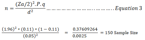
Whereas
n=Sample size
α=level of significance which can obtained as 1-confidence level (0.05)
p=Estimated of population proportion (0.11)
q=one minus estimated population proportion (1-p) equal to (0.89)
D=Margin of error (0.05)
Z=the value under the standard normal table for the given value of confidence levels (1.96)
Sampling techniques: Probability sampling techniques were used for selecting respondents to complete the questionnaire through a systematic technique and it was given equal opportunity to all populations that were selected for the sample. In this study, there are 13 Kebele and 4 Kebele were selected by simple random sampling. The selected Kebele are Bonga (335 HH), Abol (291 HH), Pinykew (254 HH) and Jewi (276 HH). The sample size was proportionally allocated to each Kebele based on the number of households in each Kebele, which were selected by systematic random sampling in this study. The study participants from each Kebele household were selected by using systematic random sampling for representation in these study areas. The questionnaires were distributed evenly through systematic techniques to the study population. Thus, a firstperson account was started randomly, following every pick for each Kebele of households in the sampling frame. Hence, to select the Kth value, the researchers used the following method:
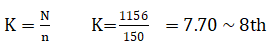
The above k values show that every 8th household was selected from each sample frame.
Results and Discussion
Cause of the forest fire
In the study area, the results show that shifting cultivation and charcoal production were selected as the leading human causes of forest fires in the study's areas by 53 (41%) and 46 (36%), respectively. The respondent stated that shifting cultivation, also known as slash-and-burn agriculture, caused the clearing of land for cultivation purposes by intentionally setting fire to the vegetation. This traditional agricultural practice in the study area often leads to uncontrollable fires that can spread rapidly and result in extensive forest destruction charcoal production, was selected as another leading cause of forest fires, according to the respondents explained that it and involves the burning of wood to produce charcoal for fuel purposes. And also, this process not only contributes to deforestation but also poses a significant fire risk. The smoking of cigarettes and the collection of honey beehives were chosen as additional human causes of forest fires by 16 (13%) and 10 (8%), respectively, the respondents stated that potential hazards of irresponsible cigarette disposal in forested areas caused by forest fire and collection of honey. This activity involves the use of smoke to calm the bees during the collection process, which, if not properly managed, can ignite nearby vegetation and trigger forest fires. Additionally, the remaining respondents (3%) electric wire as an additional factor contributing to forest fires in the study areas. This suggests that faulty electrical equipment or improper maintenance of electric wires can lead to sparks or short circuits, which, in turn, can ignite nearby flammable materials, including forests. The researcher understood that shifting cultivation was one of the main causes of forest fires, which were caused by humans. The findings were similar to those of different authors. Including a study by Belayneh et al., who stated that people start fires on purpose to clear land for agricultural cultivation, promote the growth of new grass for grazing animals, get rid of insects, parasites and wild animals, fumigate traditional beehives placed on the branches of trees to collect honey and generate charcoal production, Hauser and Norgroves stated that slash-and-burn agriculture involves the cutting down of trees and other woody plants in an area to leave the dead vegetation to dry and then burn the plant biomass (Figure 2).

Figure 2: Cause of the forest fires in the study area.
The consequence of the forest fire
The results of the study demonstrated that in the study areas, as shown in Figure 3, 40 (32%) and 35 (27%), respectively, of the respondents, chose the economic and social impact as the forest fire's major effects., respondents stated that economic and social impacts as the major effects of forest fires. These were harmful effects that forest fires have on several aspects of human life and livelihood. the reasons for the selection of economic and social impact as the major effect is the destruction of forests and other forest products. Forest fires result in the loss of valuable timber and non-timber resources, which can have severe economic implications for local communities and industries dependent on these resources. Additionally, the damage to infrastructure and property caused by forest fires further exacerbates the economic impact. Roads, buildings and other vital infrastructure may become unusable or require substantial repairs, leading to significant financial burdens on affected communities. And followed by 22 (17%) and 13 (10%) who selected climate change and settlement destruction because forest fires emit significant amounts of carbon dioxide, contributing to the greenhouse effect and exacerbating climate change. The rise in temperatures caused by these fires further intensifies the impacts of global warming. Moreover, the destruction of the forest habitat hampers biodiversity and disrupts delicate ecological balances and the remaining 11 (9%) and 7 (5%) selected soil erosion and air pollution because soil erosion can occur when the protective cover provided by trees and vegetation is destroyed. This can lead to the loss of fertile soil, making it challenging for agricultural activities and exacerbating food security concerns. Similarly, air pollution caused by forest fires can result in respiratory problems, particularly among more vulnerable populations, such as those living in forested areas. A majority of respondents generally ranked the economic and social impact as the most significant risk impact in the study areas. This finding is similar to the research study by Lemessa and Perault. It stated that the majority of farmers experience extreme economic impact when their agricultural production decreases. The loss of livestock as a result of the fires is another form of economic damage. Some livestock left the area while the fires burned in search of drier land, but some were not as successful and got destroyed in the fire.

Figure 3: Consequences of the forest fire in the study area.
Management practices by local community
According to Table 1 above, about 73 respondents (57% of the total) said that there were traditional forest management practices in the study areas, while 55 respondents (43% of the total) said that there were none. Generally, the majority of respondents indicated that there are rules and regulations by the local community to prevent forest area destruction, but they stated that some traditional forest management practices in the study areas were diminished and that some challenges contributed to the abandonment of traditional forest management practices in the study areas. These included the expansion of farmland, construction, fuel wood, charcoal, forest fire and the loss of access to forest areas. The possibility for food crop production and the reduced opportunity for harvesting products from forests, both for subsistence and income generation, as well as the loss of recreational possibilities and a benefit value that come from forest greenery and wilderness areas. These all contribute to the local community's abandonment of the forested management in the study areas. This finding is similar to the study conducted in Spain by Mico et al. This stated that the factor that contributes to the abandonment of traditional forest management practices is the introduction of intensive agricultural methods, such as overgrazing. Hindering forest generation and unplanned tourism activity, especially in forests are.
| Items | Response types | Frequency | Percentages |
|---|---|---|---|
| Are there any traditional forest management practices in the areas? | Yes | 73 | 57% |
| No | 55 | 43% | |
| Total | 128 | 100 |
Table 1: Management by local community in the study areas.
Management strategies for the forest fire
The findings obtained from the key informant interviews in Gambella Zurie Woreda by disaster and risk management experts indicated that their role in preventing forest fires was used to educate the public about how fire prevention is essential to reducing the risk of forest fires. For reduced slash and burn (shifting cultivation) and controlled gathering of honey illegally from the forest areas; safe campfire practices; forbidden throwing cigarettes under forest areas; and other activities that can cause fires. And indicated that reducing the amount of available fuel for fires can help prevent them from starting or spreading. This can be achieved through techniques such as prescribed burning, thinning and creating fire breaks.
The respondents from the environmental, forestry and climate change office experts indicated that their role in the forest management strategies was to establish nursery sites and produce seedlings to reverse the loss of forest cover through protection, restoration, afforestation and reforestation. And support traditional conservation and management, fire burning control and forest plantation. Removing the ground, appropriately separating trees, pruning trees and planting resilient trees.
In the focus group discussion, participants responded they were protecting the forest areas by keeping a close watch on the spread of fire and were controlling the fire and other activities that affect the growth of the trees in their areas. Such as due to their lack of focus on forest management and lack of funding to create plans for managing and preventing forest fires in the study area, the federal and regional governments play a minor role in the area. There are no procedures to guarantee the involvement and participation of all stakeholders in forest governance, planning and development because of insufficient funding for the creation, execution and monitoring of forest management plans. In areas with forest management plans and insufficient technological obstacles for the advancement of fire prevention, firefighting and remote sensing technologies, land managers may find other uses of the land to be more financially appealing than forest management, which could result in the degradation and deforestation of the forest.
Generation of slope, elevation and aspect
Slope: The slope is an indicator of the rate of change in elevation. And the quick spread of fires usually moved faster uphill than downhill. The slopes were reclassified into five classes. The area with the highest slope range, 25°C-35°C, was classified as low-risk due to its gentle slope, whereas the area with the lowest slope range, 0°C-5°C, was classified as high risk of forest fire due to the steepness of the slope (Figure 4 and Table 2).

Figure 4: Slope map.
| Slope (Degree) | Risk range | Fire risk values |
|---|---|---|
| 0-5°C | Very high risk | 5 |
| 5-15°C | High risk | 4 |
| 15-25°C | Moderately risk | 3 |
| 25-35°C | Low risk | 2 |
| >35°C | Very low risk | 1 |
Table 2: Slope index.
Elevation: The elevation ranges of 416 to 849 meters were classified as high-risk during the reclassified phase due to their location in the lowest elevation portion of the study area, while the elevation range of 1484 to 2083 meters was classified as lowrisk due to its area in the higher elevations of the study area. The study shows that areas with the lowest elevations are more susceptible to forest fires due to their quick spread, as indicated in the figure. Areas with the highest elevation because of the temperature variations throughout the spread of the fire (Figure 5 and Table 3).

Figure 5: Elevation map.
| Elevation (Meter) | Risk range | Fire risk value |
|---|---|---|
| 1484-2083 m | Low risk | 1 |
| 849-1484 m | Moderately risk | 2 |
| 416-627 m | High risk | 3 |
Table 3: Elevation index.
Aspect: The aspect of a sloping land, derived from Aster Dem data, influences fire behavior and fuel drying and spreading. The study found that south-east slopes receive the most sunlight, making them warmer and dryer. Direct sunlight exposure increases fire risk due to higher insolation, corresponding to wind direction (Figure 6 and Table 4).

Figure 6: Aspect map.
| Aspect class | Risk range | Fire risk value |
|---|---|---|
| Flat | Very low risk | 1 |
| North | Low risk | 2 |
| East | Moderately risk | 3 |
| West | High risk | 4 |
| South | Very high risk | 5 |
Table 4: Aspect index.
Generation of climate parameter
Temperature: The reclassified temperature maps showed that the temperature range between 18°C and 27°C, above 27°C, is associated with the highest risk of forest fire, indicating a high risk for forest fires (Figure 7 and Table 5).

Figure 7: Temperature map.
| Temperature range (°C) | Risk level | Fire risk values |
|---|---|---|
| 18-21°C | Low risk | 1 |
| 21-24°C | Moderate risk | 2 |
| 24-27°C | High risk | 3 |
Table 5: Temperature index.
Rainfall: A high risk of forest fires occurred in 921.5 mm of the rainfall shown on the classified rainfall map. The risks of forest fires are low and moderate for 1,149.8 mm and 1,741.8 mm, respectively, depending on the amount of rainfall. Each of the categories of low rainfall, moderate rainfall and greatest rainfall in the study areas. The research area as a whole is highly susceptible to forest fires due to the amount of rainfall (Figure 8 and Table 6).

Figure 8: Rainfall map.
| Rainfall range (mm) | Risk level | Fire risk value |
|---|---|---|
| 921.5-1,149.8 | High risk | 3 |
| 1,149.8-1410.3 | Moderate risk | 2 |
| 1,410.3-1,741.6 | Low risk | 1 |
Table 6: Rainfall index.
Wind speed: The reclassified wind speed map in Figure 9 shows that some areas with 1.3 m/s have a high risk of forest fire. 1.6 m/s and 1.8 m/s areas have moderate and low risks of forest fires, respectively, depending on the direction of the wind if the wind is blowing toward dense vegetation, it can increase the fire intensity and speed. And fall in the low wind speed, moderate wind speed and stronger wind speed categories, respectively. The whole study area is at high risk of a forest fire. And the stronger the wind, the faster the spread of the fire. In the present study, the lower part of the study area had a lower wind speed than the higher part, which had a higher wind speed (Table 7).

Figure 9: Rainfall map.
| Wind speed range (m/s) | Fire risk value | Risk-level |
|---|---|---|
| 1.3-1.5 m/s | 1 | Low risk |
| 1.5-1.6 m/s | 2 | Moderate risk |
| 1.6-1.8 m/s | 3 | High-risk |
Table 7: Rainfall index.
Generation of proximity data
Distance to road: The areas nearer to roads were considered more hazardous compared to others. The reclassified road distances, half of the study area, 0 to 3 km, was very high risk; 3 to 4 km and 4 to 5 km are high and moderate forest fire risk levels, respectively. And about >6 km from the road falls in a very low forest fire risk area (Table 8 and Figure 10).

Figure 10: Buffer zonation along the road.
| Road distance (Km) | Risk range | Fire risk value |
|---|---|---|
| <3 km | Very high risk | 5 |
| 3-4 km | High risk | 4 |
| 4-5 km | Moderate | 3 |
| 5-6 km | Low risk | 2 |
| >6 km | Very low risk | 1 |
Table 8: Buffer zone along roads.
Distance to settlements: The reclassified distance from settlements demonstrated that <1 km (or was at a very high risk of a forest fire. In addition, 1 to 2 km and 2 to 3 km fell at high and Moderate risk of forest fire, respectively, while the remaining 3 to 4 km and >km was at low and very low risk, that are closest to residential areas are more susceptible to fires; people traveling through the area can cause fires, intentionally or unintentionally. In the first case, they frequently set fire to clear forest paths, conceal illegal tree felling, and encroach on forest land by throwing honey and lit cigarettes (Table 9 and Figure 11).
| Settlements distance (km) | Risk range | Fire risk values |
|---|---|---|
| 0-1 km | Very high risk | 5 |
| 1-2 km | High risk | 4 |
| 2-3 km | Moderate | 3 |
| 3-4 km | Low risk | 2 |
| >4 km | Very low risk | 1 |
Table 9: Buffer zonation around settlements.

Figure 11: Buffer zonation around settlements map.
Forest fire risk map
The final forest fire risk zone map of the study areas is generated by considering fire-influencing factors such as topography and climate factors. Elevation, rainfall, slope, temperature, wind speed, distance from road and distance from settlements and aspect, were assigned different weight factors in order of their influence on occurrence of fire. Different weights were assigned to all these factors according to their sensitivity to fire or their fire-inducing capability. The forest fire risk zone map is prepared by overlaying the index map layer using the GIS tool. The study area is divided into three risk zones, ranging from low to high. Meanwhile, according to the result obtained from the weighted overlay risk class, an area of 160420.63 hectares (48.7%) was found to be in the highest risk class of forest fire and an area of about 141870.37 ha (43%), was classified as moderately risky for forest fire compared to the area with 27272.71 ha (8.3%) of forested area, which was found to have a very low risk of forest fire. The largest portions of the areas are located in the western and central parts of the study areas. The risk map of the study areas in Figure 10 clearly shows that the demarcated forest fire risk zones of the Gambella Zurie Woreda were determined using natural break reclassification methods. The results of that study reveal that 90% of the past forest fires occurred in high- and moderate-risk zones (Figures 12 and 13, Table 10).

Figure 12: Forest fire zonation map.

Figure 13: Percentage area coverage of forest fire risk zone.
| No | Class name | Risk standard |
|---|---|---|
| 1 | Elevation | 416-849 m (high risk) |
| 849-1484 m (moderate risk) | ||
| 1489-2083 m (low risk) | ||
| 2 | Rainfall | 921.5-1149.8 mm (high risk) |
| 1149.8-1410.3 mm (moderate risk) | ||
| 1410.3-1741.6 mm (low risk) | ||
| 3 | Slope | >5° (very high risk) |
| 5-15° (high risk) | ||
| 15-25° (moderate risk) | ||
| 25-35° (low risk) | ||
| >35° (very low risk) | ||
| 4 | Temperature | 18-21°C (low risk) |
| 21-24°C (moderate risk) | ||
| 24-27°C (high risk) | ||
| 5 | Wind speed | 1.3-1.5 m/s (low risk) |
| 1.5-1.6 m/s (moderate risk) | ||
| 1.6-1.8 m/s (high risk) | ||
| 6 | Distance to road | <3 km (very high risk) |
| 3-4 km (high-risk) | ||
| 4-5 km (moderate risk) | ||
| 5-6 km (low risk) | ||
| >6 km (very low risk) | ||
| 7 | Distance to settlement | <1 km (very high risk) |
| 1-2 km (high risk) | ||
| 2-3 km (moderate risk) | ||
| 3-4 km (low risk) | ||
| >4 km (very low risk) | ||
| 8 | Aspect | Flat (very low risk) |
| North (low risk) | ||
| East (moderate risk) | ||
| West (high risk) | ||
| South (very high risk) |
Table 10: The standard criteria for forest fire risk by Coban and Erdin.
Conclusion
The main aim of this study was geospatial technology-based forest fire risk assessment and mapping for sustainable forest management in Gambella Zurie Woreda, Gambella Regional State, Ethiopia. The ArcGIS spatial analysis tool was used to create a forest fire risk model, revealing high elevation, rainfall, slope, temperature and settlements as the most effective factors. The majority of the area was exposed to high and moderate fire risk levels, with 48.7% of the total area at high risk. The model's reliability was validated by fire incident points in pre-fire affected areas. GIS can aid in resource planning and management, such as inventory tracking, harvest estimation, ecosystem management and landscape and habitat planning.
Recommendations include improving fire prevention practices, implementing sustainable practices in the charcoal production sector, protecting people from fire-related effects, increasing criminal penalties for fire-starting activities, educating the local community about forest ecosystems, promoting responsible beekeeping practices, monitoring areas near settlements to prevent human causes and promoting policies based on prevention. GIS and remote sensing can integrate data about forest fires with other environmental data to improve safety and minimize fire risk.
Acknowledgements
I would like to express our special thanks to Assoc. Prof. Dr. Ajay Babu for his guidance on this research paper and for sharing his knowledge and experience with me. I also thank the local community of the Gambella woreda for their precious support in the data collection.
References
- Agbeshie AA, Abugre S, Atta-Darkwa T, Awuah R. A review of the effects of forest fire on soil properties. J For Res. 2022;33(5):1419-1441.
- Eshetu AA. Forest resource management systems in Ethiopia: Historical perspective. Int J Biodivers Conserv. 2014;6(2):121-131.
- Belayneh A, Yohannes T, Worku A. Recurrent and extensive forest fire incidence in the Bale Mountains National Park (BMNP), Ethiopia: Extent, cause and consequences. Int J Environ Sci. 2013;2(1):29-39.
- Chen F, Niu S, Tong X, Zhao J, Sun Y, He T. The impact of precipitation regimes on forest fires in Yunnan Province, Southwest China. ScientificWorldJournal. 2014;2014(1):326782.
[Crossref] [Google Scholar] [PubMed]
- Cherrington EA, Ek E, Cho P, Howell BF, Hernandez BE, Anderson ER, et al. Forest cover and deforestation in Belize: 1980-2010. SERVIR. 2010:1-42.
- Neary GD, Leonard MJ. Effects of fire on grassland soils and water: A review. Grasses and grassland aspects. 2020:1-22.
- Jaiswal RK, Mukherjee S, Raju KD, Saxena R. Forest fire risk zone mapping from satellite imagery and GIS. Int J Appl Earth Obs Geoinf. 2002;4(1):1-10.
- Kalantar B, Ueda N, Idrees MO, Janizadeh S, Ahmadi K, Shabani F. Forest fire susceptibility prediction based on machine learning models with resampling algorithms on remote sensing data. Remote Sensing. 2020;12(22):3682.
- Keenan RJ, Reams GA, Achard F, de Freitas JV, Grainger A, Lindquist E. Dynamics of global forest area: Results from the FAO Global Forest Resources Assessment 2015. For Ecol Manag. 2015;352:9-20.
- Langat DK, Maranga EK, Aboud AA, Cheboiwo JK. Role of forest resources to local livelihoods: The case of East Mau forest ecosystem, Kenya. J For Res. 2016;2016(1):4537354.
- Lemessa D, Perault M. Forest fires in Ethiopia: Reflections on socio-economic and environmental effects of the fires in 2000. UN-Emergencies Unit for Ethiopia & Matthew Perault, Brown University, Providence, USA. 2001.
- Livingstone J, Kassa H, Yimam K, Hagazi N, Shibeshi A, Zewdie S. Fire management in Ethiopia: Past, present and future. Trop For. 2022(2022):61.
- McGuire S. FAO, IFAD, and WFP. The state of food insecurity in the world 2015: Meeting the 2015 international hunger targets: Taking stock of uneven progress. Rome: FAO, 2015. Adv Nutr. 2015;6(5):623-624.
[Crossref] [Google Scholar] [PubMed]
- Othow OO, Gebre SL, Gemeda DO. Analyzing the rate of land use and land cover change and determining the causes of forest cover change in Gog district, Gambella regional state, Ethiopia. J Remote Sens GIS. 2017;6(4):218.
- Sun X, Huang H, Zhao J, Song G. Experimental study of the effect of slope on the spread and burning characteristics of a continuous oil spill fire. Fire. 2022;5(4):112.
- Thakur JK, Singh SK, Ekanthalu VS. Integrating remote sensing, geographic information systems and global positioning system techniques with hydrological modeling. Applied Water Science. 2017;7(4):1595-1608.
- He T, Lamont BB, Pausas JG. Fire as a key driver of Earth's biodiversity. Biol Rev Camb Philos Soc. 2019;94(6):1983-2010.
[Crossref] [Google Scholar] [PubMed]
Citation: Gach DD (2025) Geospatial Technology-Based Forest Fire Risk Assessments and Forest Management in Gambella Woreda, Gambella Regional State, Ethiopia. J Remote Sens. 14:358.
Copyright: © 2025 Gach DD. This is an open-access article distributed under the terms of the Creative Commons Attribution License, which permits unrestricted use, distribution and reproduction in any medium, provided the original author and source are credited.