Indexed In
- Open J Gate
- RefSeek
- Hamdard University
- EBSCO A-Z
- OCLC- WorldCat
- Publons
- International Scientific Indexing
- Euro Pub
- Google Scholar
Useful Links
Share This Page
Journal Flyer

Open Access Journals
- Agri and Aquaculture
- Biochemistry
- Bioinformatics & Systems Biology
- Business & Management
- Chemistry
- Clinical Sciences
- Engineering
- Food & Nutrition
- General Science
- Genetics & Molecular Biology
- Immunology & Microbiology
- Medical Sciences
- Neuroscience & Psychology
- Nursing & Health Care
- Pharmaceutical Sciences
Research Article - (2024) Volume 13, Issue 1
Geochemical Variability and Spectral Analysis of a Core from the El-Guettiate Sebkha in the Mediterranean Saline System during the Holocene
Najia Bouabid1,2*, Feyda Srarfi3 and Mohamed Ali Tagorti42Department of Geology, University of Gabès, Zrig Eddakhlania, Tunisia
3Department of Science of Tunis, El Manar University, Tunis, Tunisia
4Department of Geology, University of Tunis El Manar, Tunis, Tunisia
Received: 02-Jan-2024, Manuscript No. JGRS-24-24537; Editor assigned: 05-Jan-2024, Pre QC No. JGRS-24-24537 (PQ); Reviewed: 19-Jan-2024, QC No. JGRS-24-24537; Revised: 26-Jan-2024, Manuscript No. JGRS-24-24537 (R); Published: 02-Feb-2024, DOI: 10.35248/2469-4134.24.13.328
Abstract
The aim of this research is to examine the regularity of physico-chemical variables, magnetic susceptibility and carbonate levels on a 100 cm core from the El-Guettiate sebkha in the Skhira region (south-east Tunisia). Spectral analysis of the parameters studied revealed numerous cycles. The variation in CaCO3 concentration along the core shows significant variability. This variability is due to a radical change in the geochemistry and composition of the sediments as a result of changing climatic conditions. Spectral analysis results in this work can be performed by magnetic susceptibility and sodium shows a cycle of 1000 years and 1300 years. Significant cycles were not identified through spectral analysis of the potassium data. Also carbonate and calcium showed double cycles of 1600 years to 860 years and 1700 years to 889 years. Climate cycle factors are related to solar activity, ocean and atmosphere.
Keywords
Spectral analysis; Geochemical; Sebkha El-Guettiate; Holocene
Introduction
According to paleoclimatic research, the Quaternary, more precisely the Holocene, covers around 10,000 years BP. All these studies have opted for the Holocene because of its duration and apparent climatic stability. Today, however, the Holocene is considered a period characterized by rapid climatic variability. For this reason, numerous studies have been carried out over the last few decades to understand the Quaternary and present-day environments. However, many studies have focused on wetlands, which are considered a complex and vulnerable ecosystem in particular sebkhas and the evolution of Tunisian coastal systems during the Holocene [1].
Coastal marine ecosystems are generally considered to be the most vulnerable. Due to rapid industrialization, the amount of toxic chemicals and metals in coastal ecosystems has increased [2-4]. Climate change is affecting global water and air circulation. However, some regions react quickly, while others have to wait a while before changing their deposition record. North Africa is an area vulnerable to climate change and is the first region of the Mediterranean basin to be affected [5]. For both academic and practical reasons, saline systems have been a popular subject of study. They produce economically valuable brines and evaporated minerals [6].
In general, local tectonic, global eustatic and local climatic factors have driven Holocene sedimentation in southeast Tunisia [7]. Spectral analysis of the different parameters recorded from Holocene deposits, either buried in sebkhas or in outcrop, allows us to determine that these factors guarantee climatic cyclicity [8]. The aim of this research was to examine Holocene cyclostratigraphy on a core belonging to a semi-exoric system of the El-Guettiate sebkha, located on the Mediterranean coast.
Study area
The El-Guettiate sebkha, the subject of this work, is a coastal depression located in south-eastern Tunisia. Covering an area of 15 km2, its boundaries are bounded by the Sfax plain to the north, the Mediterranean Sea to the east, El-Hicha lagoon to the south, and the BouSaïd plain to the west. The study area includes the Oum El Ghram and BouSaïd basins in south-eastern Tunisia. It has a semi-arid climate characterized by irregular rainfall with an annual average of around 200 mm (Institute national de Meteorology de Sfax). In geological terms, the region features a variety of formations ranging from the Lower Cretaceous to the Quaternary [9,10].
The Upper Cretaceous is characterized by a dominance of carbonates with intermittent clay intercalations, while the Lower Cretaceous strata comprise detrital and carbonate deposits. In addition, the alluvial marls and limestones along the coastal strip are part of the Mio-Pliocene series [11-15]. The sebkha is separated from the Mediterranean by a narrow cliff 2 km long and 100 m to 200 m wide, which collapses due to wave action.
A 2 km long spit of sand connects this cliff to the south. The sebkha communicates with the Mediterranean via a tidal channel 10 m wide and 7 m deep. The transport of Sebkha surface sediments brings out the deeper sediments through numerous tidal channels, which are influenced by both tidal and fluvial inputs. A system of schorres and slikkes characterizes the central part of the sebkha. The schorres are occupied by halophilic vegetation, mainly composed of saltwort. Elliptical troughs develop on the surface of the schorre. These troughs are shallow (10 cm to 30 cm), 0.5 m to 3 m wide and elliptical in shape (Figure 1) [16].
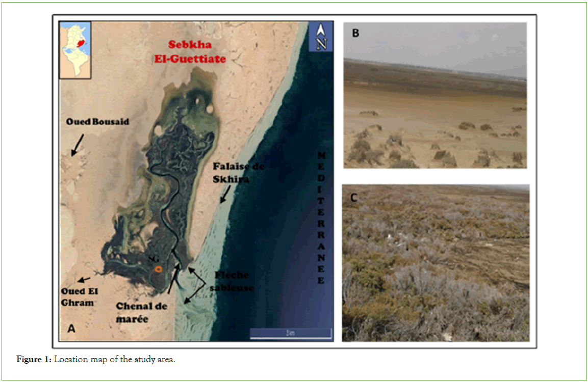
Figure 1: Location map of the study area.
Materials and Methods
A 100 cm core was produced in the El-Guettiate sebkha during field expeditions. Sampling was carried out in the laboratory every 0.5 cm to obtain 200 cm samples. We then measured MS magnetic susceptibility, CaCO3, chemical element concentrations, SEM and mineralogical analysis was carried out by X-ray diffraction (XRD) analysis with a Type “PANalytical” Pro, at the Laboratory de Mineral Resources et Environment of the Faculty des Sciences de Tunis. The mineralogical proportions of the minerals were determined using X’PERT HighScore Plus software.
We based our present work on the dating of Zaïbi et al. as our core (100 cm) was compared in length and proximity [17]. Tephrochronological dating revealed a sedimentation rate of around 0.32 mm per during the Upper Holocene at Sebkha El- Guettiate, so we can designate an age-depth model to complete the temporal spectral analysis of this sebkha.
We use spectral analysis and Principal Component Analysis (PCA) to process the data obtained. The PAST program was used to perform the spectral analysis.
Results and Discussion
Sediment mineralogy, geochemistry and magnetics were used to infer lithofacies and depositional environments
According to the mineralogical analysis of Sebkha El-Guettiate, the diffractogrammes of SG core sediments studied at a depth of 60 cm identified silicates, carbonates and evaporites. These results are characterized by the presence of mineral percentages. The majority of Quartz peaks were found to be between 76% (SG-160) and 98% (SG-40). However, analysis of the carbonate minerals (calcite, dolomite, magnesium and Ankerite) shows significant peaks at the middle beginning of cores SG-80, SG-100, SG-120, SG-140 and SG-160. In addition, evaporites (gypsum and halite) (SG40 and SG-180) were the most dominant X-ray diffraction peaks (Figure 2).
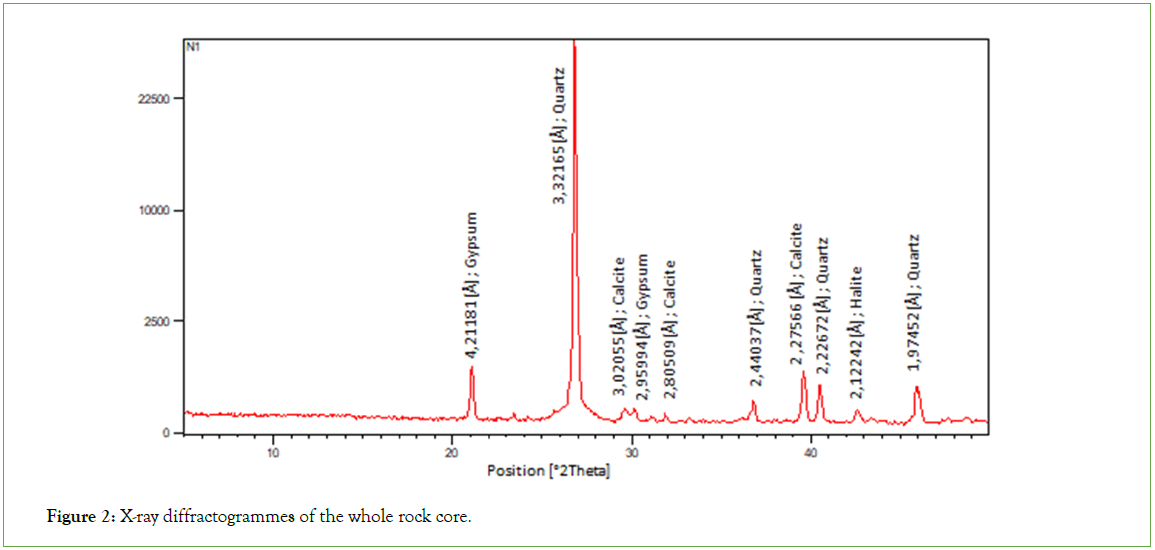
Figure 2: X-ray diffractogrammes of the whole rock core.
Images of the Sebkha sediments were examined by scanning electron microscopy after mineralogical compositions had been determined. According to the results of the SEM images, representations of quartz minerals are generally present throughout the samples. In addition, clay types such as illite were observed, and a pyrite mineral (FeS2) in automorphic form was also observed (sample SG-150). But almost all samples contain rhombohedra crystals of carbonate minerals, such as calcite and dolomite. However, almost all samples are represented as cubic crystals, as evaporite minerals (gypsum and halite) can surround quartz crystals. Gypsum is present as white crystalline lamellae in samples from SG-100 to SG-200 (Figure 3).
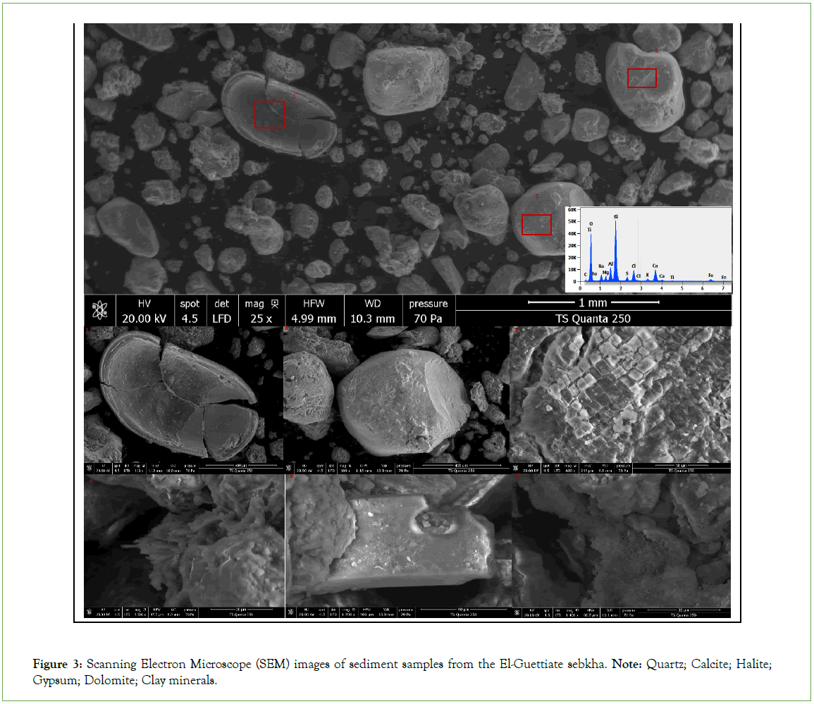
Figure 3: Scanning Electron Microscope (SEM) images of sediment samples from the El-Guettiate sebkha. Note: Quartz; Calcite; Halite; Gypsum; Dolomite; Clay minerals.
Figure 4, shows Ca, K and Na concentrations (mg/kg) throughout the sebkha El-Guettiate core. With the exception of depth intervals 0-5 cm, 15-35 cm, 50-70 cm and the lower level, the sediments show high sodium and low calcium concentrations. High Ca concentrations in the lower and upper centimetres are most often followed by an increasing trend in halite concentration (0-5 cm and 6-30 cm depth). Potassium shows an increasing trend in the 5 cm to 20 cm, 22 cm to 28 cm and 65 cm to 80 cm interval and the rest of the core indicates low concentration variability.
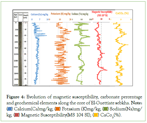
Figure 4: Evolution of magnetic susceptibility, carbonate percentage
and geochemical elements along the core of El-Guettiate sebkha. Note:  Sodium(Na)mg/kg;
  CaCO3(%).
The percentage of CaCO3 in the core varies from 6% to 34%. However, the first 10 cm have high carbonate content, with an average of 18%. The second interval extends to 40 cm and is characterized by an increase in the carbonate percentage. The first and second intervals are repeated until the end of the sebkha core to indicate the establishment of revealing conditions at the top of the core. We note that the variation in carbonate percentage is probably due to solar activity. Consequently, high values indicate an arid climate and low values indicate a humid climate.
The magnetic susceptibility of the sediment samples varies from 13 10-6 SI to 45 10-6 SI along the length of the sebkha core. Indeed, the greatest depths were recorded at 19 cm to 79 cm, while the lowest were recorded at 0-18 and 80 to the end of the core (Figure 4).
Holocene cyclicity
Na and Ca: The main factors involved in climate change in the El-Guettiate sebkha (south-eastern Tunisia) were identified using spectral analysis. PAST software reveals important climatic factors by processing chemical element percentage values. Calcite and gypsum, the symbols of precipitated evaporite minerals, were present. Plagioclase feldspar, the main source of Na, decomposes easily by hydrolysis when sufficient moisture is available, releasing water.
The individualization of a cycle extends 1300 years, according to sodium-based spectral analysis. On the other hand, the individualization of two cycles extends over approximately 1000 years and 1700 years, according to calcium-based spectral analysis. Numerous other studies have established a cycle of around 500 years [18].
Several studies of the North Atlantic and Mediterranean regions indicate that the 1000 years and 1300 years cycles have a probable link with ocean circulation and solar activity (Figures 4 and 5) [19- 22].
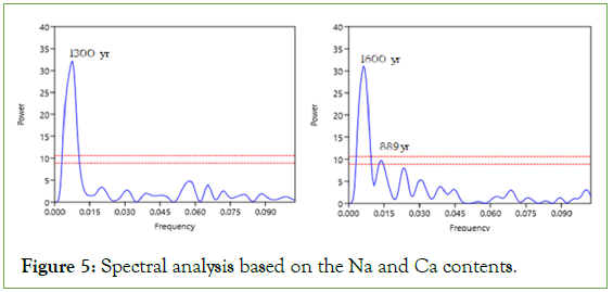
Figure 5: Spectral analysis based on the Na and Ca contents.
SI and CaCO3: Spectral analysis of the data for the various parameters can highlight the cyclicity clearly identified along the core. However, the spectral analysis of magnetic susceptibility shows that the individualization of a cycle extends over about 1000 years.
Zaibi dating, 2011 used to estimate the age-depth model of the El-Guettiate sebkha. In contrast, spectral analysis of carbonate percentage data reveals the individualization of two cycles spanning 1600 years and 860 years.
The second harmonic of the 1500 years cycle of oceanic thermohaline circulation is barely attributed to the 700 years cycle [23]. This cycle may also indicate a close link between the Indian Ocean and African rainfall. It may also be the result of a coupling between the Indian Ocean and African precipitation, or it may be the result of the coupled ocean-atmosphere variability that is inherent in the tropical monsoon system [24]. With regard to the 1700 years cycle highlighted a frequency of 1660 years using sediment colour as an indicator of carbonate content (Figure 6) [25].
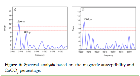
Figure 6: Spectral analysis based on the magnetic susceptibility and CaCO3 percentage.
Principal component analysis applied to the sediment samples highlighted the various parameters (magnetic susceptibility, carbonate percentage, calcium, sodium and potassium content). Projection of the variables onto the factorial plane (1 × 2) shows that the main axis accounts for more than 51.64% of the total variance.
Figure 7, shows that the results for these sebkha El-Guettiate parameters prove that Magnetic Susceptibility (MS) is anti-correlated with sodium level, calcium level and carbonate percentage. The PCA demonstrated that fluctuations in carbonate content can explain the climatic variability represented by magnetic susceptibility as an indicator of climate change. During wet periods, the hydrographic network brings sediments from the vicinity of the continent, which increases the rate of magnetic matter and causes the dissolution of CaCO3 and mineral salts. In arid periods, MS values decrease due to the deposition of diamagnetic materials such as carbonate and quartz, but the percentage of CaCO3 and the rate of mineral halite increase considerably (Figure 7) [26].
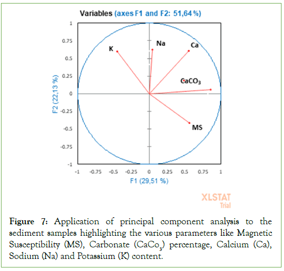
Figure 7: Application of principal component analysis to the sediment samples highlighting the various parameters like Magnetic Susceptibility (MS), Carbonate (CaCO3) percentage, Calcium (Ca), Sodium (Na) and Potassium (K) content.
Conclusion
The study of the El-Guettiate sebkha allows us to visualize the presence of a wet soil by examining mineralogical data, carbonate levels, geochemical elements (Na, K and Ca) and magnetic susceptibility. According to the mineral parameter evaluation study, evaporites (halite, gypsum), silicates (quartz and feldspar) and carbonates (calcite, dolomite and magnesian) constitute the nonclay minerals. As a general rule, variation in carbonate (CaCO3) content indicates that high levels of CaCO3 indicate a dry climate, while low levels indicate carbonate dissolution in a humid climate.
Calcium data and carbonate percentages showed double cycles, from 1600 years to 860 years and from 1700 years to 889 years, respectively. But potassium data showed no significant cycles. However, the 1000 year and 1300 year cycle was highlighted by spectral analysis of magnetic susceptibility and sodium data.
Consequently, Holocene cyclostratigraphy is the result of combined solar activity, oceanographic and atmospheric conditions.
Acknowledgments
Dr. Ahmed Hichem Hamzaoui, Bachir Slimi, and Ramzi Ben Massoud for their help and assistance in the geochemical field and mineralogical analysis at the Borj Cedria Technopole Center, and to Mr. Mohamed Lassoued director of CRDA Sfax, Dr. Mabrouk Boughdiri chef Department de faculty of sciences of Bizerte University of Carthage Tunis and Dr. Elhoucine Essefi for his contribution to the missions sampling.
Author Contributions Statement
The authors significantly contributed to preparing, writing, and revising the manuscript. Najia Bouabid contributed to data interpretation and wrote the major manuscript, sampled, data collection and analyses. Feyda Srarfi contributed to writing and revising the manuscript. Mohamed Ali TAGORTI revised the manuscript. All authors read and approved the final manuscript.
Declarations
Conflict of interest
The authors declare no competing interests.
Funding
There is no funding for this work.
Data availability
The datasets used and analysed during the current study are available from the authors on reasonable request.
References
- Mosbah CZB, Ismaïl‑Lattrache KB, Gueddari M, Reyss JL. Évolution biosédimentaire du dépôt quaternaire de la lagune de l'Ariana, Tunisie (une zone humide du Maghreb Nord). Quaternaire. Revue de l'Association française pour l'étude du Quaternaire. 2010;21(2).
- Hu C, Yang X, Dong J, Zhang X. Heavy metal concentrations and chemical fractions in sediment from Swan Lagoon, China: Their relation to the physiochemical properties of sediment. Chemosphere. 2018;209:848-56.
[Crossref] [Google Scholar] [PubMed]
- Mosbahi N, Serbaji MM, Pezy JP, Neifar L, Dauvin JC. Response of benthic macrofauna to multiple anthropogenic pressures in the shallow coastal zone south of Sfax (Tunisia, central Mediterranean Sea). Environmental Pollution. 2019;253:474-487.
[Crossref] [Google Scholar] [PubMed]
- Zaaboub N, Martins MV, Dhib A, Béjaoui B, Galgani F, El Bour M, et al. Accumulation of trace metals in sediments in a Mediterranean Lagoon: Usefulness of metal sediment fractionation and elutriate toxicity assessment. Environmental Pollution. 2015;207:226-237.
[Crossref] [Google Scholar] [PubMed]
- Raymond F, Ullmann A. Impact spatial du changement climatique sur les sécheresses hivernales en Méditerranée et ses conséquences sur l’agriculture. Les impacts spatiaux du changement climatique. 2021;211.
- Tagorti MA, Essefi E, Touir J, Guellala R, Yaich C. Geochemical controls of groundwaters upwelling in saline environments: Case study the discharge playa of Sidi El Hani (Sahel, Tunisia). Journal of African Earth Sciences. 2013;86:1-9.
- Lakhdar R, Soussi m. Les dépôts lagunaires holocènes du Sud-Est de la Tunisie: extension et organisation spatio-temporelle. InConférence Méditerranéenne Côtiere et Maritime. 2009;115-118.
- Azuara J. L'influence du climat et des activités humaines sur l'histoire holocène de la végétation du nord-ouest de la Méditerranée (Doctoral dissertation, Museum national d'histoire naturelle-MNHN PARIS). 2017.
- Burollet PF. Contribution à l'étude stratigraphique de la Tunisie centrale. Ann. Mines Géol.. 1956;18:350.
- Hajjem A. Étude hydrogéologique préliminaire de la nappe de Chaffar (Sahel Sud de Sfax). Sfax: Commissariat régional de développement agricole (CRDA), Arrondissement des eaux. 1985.
- M'Rabet A. Stratigraphie, sédimentation et diagenèse carbonatée des séries du Crétacé inférieur de Tunisie centrale. 1987 ;385
- Abbes C, Zargouni F. Anatomie d’un couloir de décrochements: le couloir de Hadifa (Chaîne Nord des Chotts-Tunisie). Rev. Sc. de la Terre. 1986;4.
- Louhaichi MA, Tlig S. Tectonique synsédimentaire des séries crétacées post-barrémiennes au Nord-Est de la Chaîne des Chotts (Tunisie méridionale). Géologie méditerranéenne. 1993;20(1):53-74.
- Gharbi M. Relationship between the southern Atlas foreland and the eastern margin of Tunisia (Chotts-Gulf of Gabes): Tectono-sedimentary, fault kinematics and balanced cross section approaches. 2013.
- Boukhalfa K, Li G, Ali WB, Soussi M. Early Cretaceous spinicaudatans (“conchostracans”) from lacustrine strata of the Sidi Aïch Formation in the northern Chotts range, southern Tunisia: taxonomy, biostratigraphy and stratigraphic implication. Cretaceous Research. 2015;56:482-490.
- Zaîbi C, Kamoun F, Carbonel P, Montacer M. Distribution des ostracodes dans les sédiments de subsurface de la Sebkha El-Guettiate (Skhira, golfe de Gabès). Intérêt pour la reconstitution des paléo-environnements de l'Holocène. 2011;3:63-81.
- Dean WE. Rates, timing, and cyclicity of Holocene eolian activity in North-Central United States: Evidence from varved lake sediments. Geology. 1997;25(4):331-334.
- Carcaillet C, Bouvier M, Fréchette B, Larouche AC, Richard PJ. Comparison of pollen-slide and sieving methods in lacustrine charcoal analyses for local and regional fire history. The Holocene. 2001;11(4):467-476.
- Bond G, Kromer B, Beer J, Muscheler R, Evans MN, Showers W, et al. Persistent solar influence on North Atlantic climate during the Holocene. Science. 2001;294(5549):2130-2136.
[Crossref] [Google Scholar] [PubMed]
- Moreno A, Cacho I, Canals M, Grimalt JO, Sánchez-Goñi MF, Shackleton N, et al. Links between marine and atmospheric processes oscillating on a millennial time-scale. A multi-proxy study of the last 50,000 yr from the Alboran Sea (Western Mediterranean Sea). Quaternary Science Reviews. 2005;24(14-15):1623-1636.
- Debret M, Bout-Roumazeilles V, Grousset F, Desmet M, McManus JF, Massei N, et al. The origin of the 1500-year climate cycles in Holocene North-Atlantic records. Climate of the Past. 2007;3(4):569-575.
- Pena LD, Francés G, Diz P, Esparza M, Grimalt JO, Nombela MA, et al. Climate fluctuations during the Holocene in NW Iberia: High and low latitude linkages. Continental Shelf Research. 2010;30(13):1487-1496.
- Jian Z, Wang P, Saito Y, Wang J, Pflaumann U, Oba T, et al. Holocene variability of the Kuroshio current in the Okinawa Trough, northwestern Pacific Ocean. Earth and Planetary Science Letters. 2000;184(1):305-319.
- Russell JM, Johnson TC. A high-resolution geochemical record from Lake Edward, Uganda Congo and the timing and causes of tropical African drought during the late Holocene. Quaternary Science Reviews. 2005;24(12-13):1375-1389.
- Chapman MR, Shackleton NJ. Evidence of 550-year and 1000-year cyclicities in North Atlantic circulation patterns during the Holocene. The Holocene. 2000;10(3):287-291.
- Essefi E, Gharsalli N, Kalabi S, Ben Ameur M, Yaich C. Spectral analysis of a core from the Sebkha of Sidi Mansour, southern Tunisia: The Holocene cyclostratigraphy. J. Remote Sens. GIS. 2015;4:141.
Citation: Bouabid N, Srarfi F, Tagorti MA (2024) Geochemical Variability and Spectral Analysis of a Core from the El-Guettiate Sebkha in the Mediterranean Saline System during the Holocene. J Remote Sens GIS. 13:328.
Copyright: © 2024 Bouabid N, et al. This is an open access article distributed under the terms of the Creative Commons Attribution License, which permits unrestricted use, distribution, and reproduction in any medium, provided the original author and source are credited.

