Evidence of Tornadoes Reaching the Countries of Rio Branco do Ivai and Rosario de Ivai, Southern Brazil on June 6, 2017
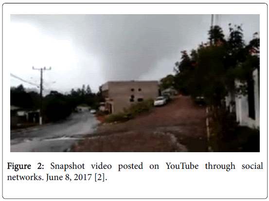
IntroductionEditA vortex originating from a cumulonimbus cloud, tapering toward the ground, and touching it is called a tornado. Feared and admired by man, the tornado is an atmospheric phenomenon that can cause a catastrophe to pass through [1]. If it reaches an unsuspecting and unprotected population on inhabited urban and rural properties, it can lead to human losses and serious material damage. It causes serious losses with the death of wild and farmed animals [1]. On June 6, 2017, an alleged tornado hit the municipalities of Rio Branco do Ivaí and Rosario do Ivaí, located in the state of Paraná, southern Brazil. The images of the alleged tornado have been disseminated on social networks and in several newspapers in the country [2,3]. Videos with one or more alleged tornadoes were made and disseminated on social networks such as youtube, whatsapp, facebook, blogs, among others, by several residents of stricken cities, on the afternoon of June 6, 2017, in the municipalities of Rio Branco do Ivaí and Rosário do Ivaí [2,3]. Local officials reported the damage caused by the alleged tornado, causing a large number of homeless, with the destruction of houses, as well as the killing of animals and the destruction of rural properties. The occurrence of tornado had not been confirmed by the country's meteorological institutes [2-4]. A search was initiated to verify the probable cause of the losses and damages caused in these municipalities, by the supposed tornado. The videos posted by the local residents on social networks [2-4] and images obtained by meteorological satellites were collected on the REDEMET website, in the visible spectrum and highlighted infrared channel, as well as the image of the GOES 13/NOAA/USA-Infrared Channel highlighted [5]. The meteorological phenomenon caused the destruction of urban properties - with the destruction of houses, and in the gymnasium of sports, that was completely destroyed. In rural properties and localities, property damage and the death of livestock and wild animals, causing counties of Rosário do Ivaí and Rio Branco do Ivaí [2-4]. |
TornadoesEditA tornado is the most violent windstorm on earth [1]. Tornadoes are rapidly rotating columns of air that make contact with the ground. Consider them to be intense, columnar vortices in contact with the ground that are capable of inflicting damage. They are either connected to or are situated underneath a cumuliform, buoyant convective cloud above. Tornadoes are sometimes, but not always, visible as a funnel cloud when the pressure deficit in them is low enough that water vapor condenses and cloud particles form. When the air is too dry or the pressure not low enough for a condensation funnel to form or to extend down to the ground, the tornado may be visualized as a column of rotating dust or debris or not visualized at all if there are no visible particles available to be lofted. In some instances they are encased in precipitation (‘‘rain-wrapped’’) and either not visible at all or visible only from a restricted viewing angle [6]. Tornadoes come in many colors, shapes and sizes. Some are gray, white, or even a pale shade of blue. Others are difficult to see until they pick up dirt or other debris, taking on the color of the soil, like brownish-red, or black. Tornadoes often resemble a long, thin tube sweeping across the sky. Some have a classic funnel shape-wide at the top and narrow at the bottom. Still, other tornadoes are as wide as they are tall, and are hard to tell apart from their parent storm cloud [1]. All tornadoes are triggered by thunderstorms, but only the very biggest thunderstorms trigger tornadoes. Thunderstorms begin when unstable air rises. To be “unstable,” a deep layer of air must be less dense than the air immediately above it. Being less dense, it rises as denser air sinks beneath it and raises it. It goes on rising until it lies beneath air that is less dense than it, and therefore can rise no higher [6-31]. Its rise may begin when the ground in a particular location is warmed strongly by the Sun. The warmed air expands and this makes it less dense than the air above it, so it is pushed upward. That is how summer storms begin. Alternatively, moving air may be forced to rise as it crosses hills or mountains, and warm air may be lifted by denser air at an advancing cold front [6-30]. Just because air is forced to rise, it does not follow that a thunderstorm will develop or, indeed, that any kind of clouds will form. If stable air is made to rise, it will reach a level beyond which it can rise no higher, then sink again. As it rises, the air cools adiabatically and as it sinks it warms [6-30]. According to the Fujita Scale upon which the “F5” classification is based, such a tornado can flatten homes, turn cars into airborne missiles, and debark trees. The Fujita Scale is a widely accepted “damage scale” for categorizing tornadoes that’s based on the havoc they wreak, and “F5” is used only to identify the most destructive rotating winds - those that spin anywhere from an estimated 261 to 318 miles per hour. Created by University of Chicago meteorologist Tetsuya “Ted” Fujita in 1971, the scale’s other five categories also use damage characteristics and estimated speeds to classify every other tornado: F0 (under 73 miles per hour); F1 (73 to 112 miles per hour); F2 (113 to 157 miles per hour); F3 (158 to 206 miles per hour); and F4 (207 to 260 miles per hour). In 2007, the “F-scale” was supplanted by a slightly modified “Enhanced Fujita Scale or “EF-scale (for consistency I’ve stuck with the F-scale, which was in use for most of my early days of storm chasing, throughout this book). Whichever scale you use, to suggest “F5” is to suggest almost unfathomable power [6-33]. Tornadoes occur on all continents. In Brazil, they are infrequent and occur mainly in the South and Southeast regions, especially in São Paulo, Rio Grande do Sul, Santa Catarina and Paraná [34]. The Meteorological centers are able to warn a few hours in advance of the formation of severe storm clouds because they do not yet have the necessary technologies to warn about tornado formation well in advance [34,35]. During the period from 1980 to 2007, the total number of natural disasters in all affected municipalities of the State of Santa Catarina, according to data from the Damage Assessment Forms (AVADANs) obtained in the Civil Defense of the State, were: 422 of hail, 549 of vendors and 43 episodes of tornadoes. As of 1998, 28 episodes of storm tides were also recorded, highlighting in 2004 the unprecedented episode of Hurricane Catarina [36,37]. |
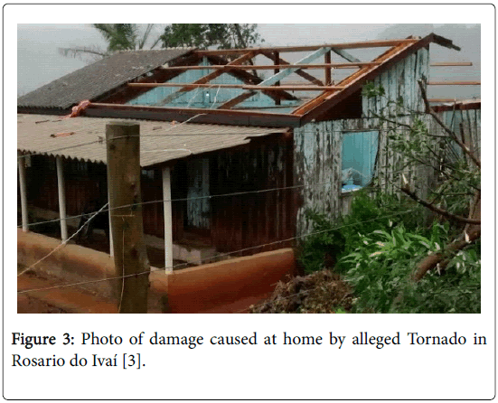
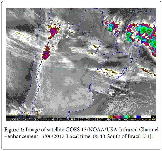
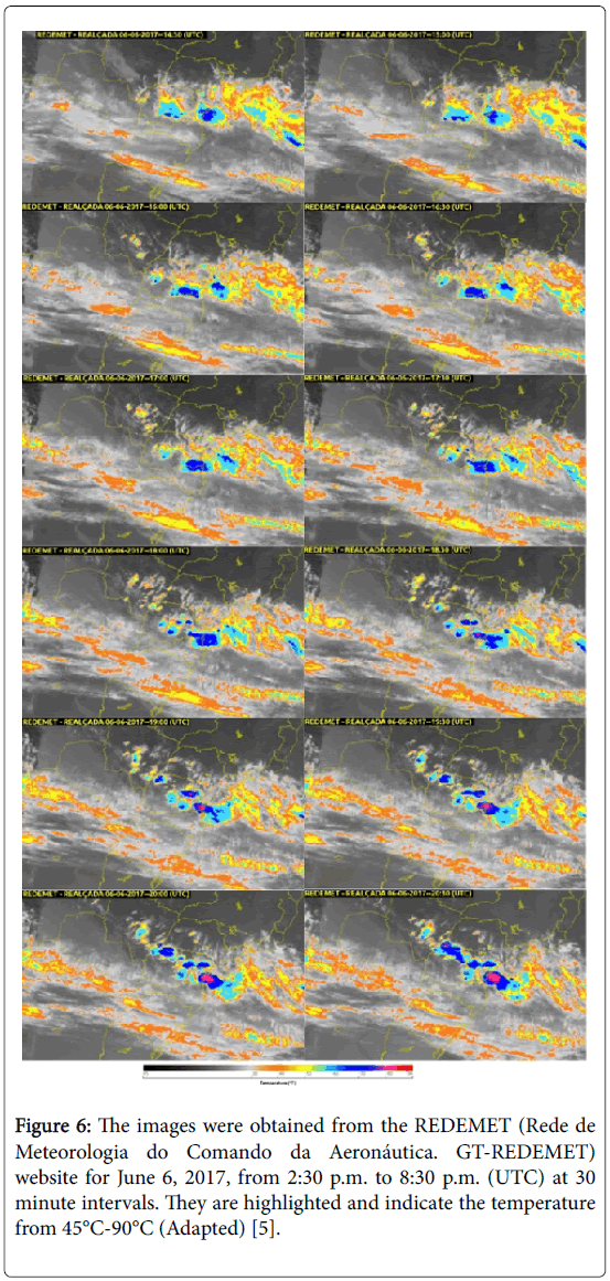
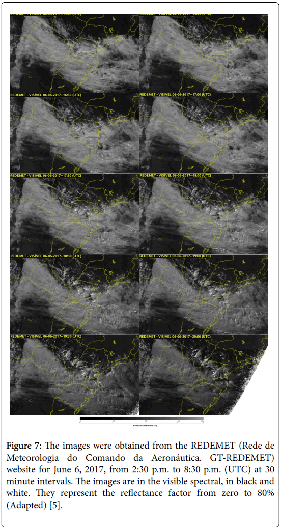
MethodsEditCollected data and evidence Supposed tornado causes damage in the interior of Parana: An alleged tornado hit the city of Rio Branco do Ivaí, north of Paraná, on Wednesday afternoon [7], according to the city's municipality. The Simepar Meteorological Institute said it has not yet evaluated the phenomenon. "We have not had information yet, let's look at the case," said meteorologist S Paz, According to the mayor of the municipality, GC Rosa, the strong wind caused havoc in the city. "We had damages in the gymnasium of sports, our block was completely destroyed and six houses were discovered, mainly in the rural town D Izalino. Trees fell and interdicted streets, utility poles were damaged leaving part of the city without electricity grid, "he said. A city hall staff works to free the interdicted places. The orientation of the city hall is that the affected families seek the Civil Defense and the Social Action Secretariat of the municipality. The bulletin released at 12th this Thursday [8] by the Civil Defense of Paraná indicates that 20 people were hit and seven houses were damaged [2]. Thunderstorm: Gale in Rosario do Ivai and Rio Branco do Ivai: In Tuesday, June 6, 2017 reports of residents of some neighborhoods, such as Caneleira and Vila União (Rosario do Ivaí), are that animals that died and houses were damaged. In Rio Branco Ivaí, there were also havoc and images of a funnel cloud. Residents of Rural Districts of Rosario de Ivaí, called the report of the Blog of Berimbau and Radio Nova Era, to report that a gale hit some locations, among them Bairro da Caneleira and Vila União. "It looked like a tornado, it was taking everything, destroying houses and even causing animals to die, like cattle," said a farmer living in Vila União. Another rural producer said tomato greenhouses and other cultures, have also been damaged. By telephone, H Sílva, a contributor to our report, also brought personal accounts of the affected regions, narrating the moments of fear and concern. In Rio Branco do Ivaí, it also rained hard and residents came to make the video of a cloud funnel, stating that it was a tornado. The mayor issued a note, through the advisor F Barbosa, with the following information: "Rio Branco do Ivaí was hit by a tornado; houses were discovered in the Rural Village D Izalino and next to the gymnasium of sports Cidão. A few days later, our press office together with sports secretary, Mr. G Oliveira, were in the affected areas, thank God no one was injured, only material damages. M Gerôncio was also accompanying and lamented the fact, "says a note from the city of Rio Branco. (Collaboration of P Gruber and Letícia, from Rio Branco do Ivaí, and H Silva, Rosario, and Soldiers from cup officer on duty [3]. Forecasting for Tuesday, June 6, 2017: With the accumulated rains of yesterday and this dawn we have already passed from the expected to the month of June. This autumn has already surpassed the autumn of last year, which had already been rainy in the months of April and May. The fall of this year already had rain above the historical average in the month of April (35%), May (155%) and June until today in the morning (3%). The current national climate models put rain above the historical average for that month, around 50 mm, not reached until that moment. Normality for the month of July and above the average for August. We are in climatological neutrality with a tendency to warm up, but without reaching the El Niño [31]. Analysis of images For the accomplishment of this work the images of satellite GOES 13/NOAA/USA-Infrared Channel more enhancement, available 06/06/2017, local time: 06:40, South of Brazil. Central and South America and the Caribbean, Cooperative Institute for Research in the Atmosphere, Colorado State University, USA, modified by LabClima/ UNIVALI., (Figure 4). A reanalysis of the National Centers for Environmental Prediction (NCEP) model. The processing and analysis of the data were performed in the decoded and separated into their quantified RGB color channels. The technique consists of the analysis of the pixels of the images of primary light sources [32]. The images were obtained from the REDEMET (Meteorology Network of the Aeronautics Command) website for June 6, 2017, from 2:30 p.m. to 8:30 p.m. (UTC) at 30 minute intervals. The images are in the visible spectral, in black and white. They represent the reflectance factor from zero to 80%. The images were obtained from the REDEMET (Rede de Meteorologia do Comando da Aeronáutica. GTREDEMET) website for June 6, 2017, from 2:30 p.m. to 8:30 p.m. (UTC) at 30 minute intervals. They are highlighted and indicate the temperature from 45°C-90°C. The analyzes of the GOES-13 satellite were used observing the formation and dissipation of the storm along 06/06/2017, with a temporal resolution of approximately every 30 minutes. Then, the gray level (Nc), for the brightness temperature (Tb) was analyzed using the following equation: Tb=320-(0.625 Nc) (1) The images analyzed for Tb were classified in order to find areas that had the lowest Tb values, thus indicating more intense convection. The classification adopted was unsupervised, that is, the user does not properly determine the classes that are to be found by the classifiers [33]. |
Location of the Municipalities of Rio Branco do Ivaí and Rosario do IvaiEditRio Branco do Ivai It has an area of 386 km² representing 0.1935% of the state, 0.0684% of the region and 0.0045% of the entire Brazilian territory. It is located at latitude 24°19'26"south and a longitude 51°18'46" west, being at an altitude of 650 m. Its estimated population in 2000 was 3,758 inhabitants. Rosário do Ivaí The municipality is characterized by a fairly rugged relief, in which approximately 50% of the area of the Municipality is under the phases of the strong undulating and mountainous relief, 29% is under soft undulating relief and 21% under undulating relief. It has an area of 371,248 km² representing 0.1863% of the state, 0.0659% of the region and 0.0044% of the entire Brazilian territory. It is located at latitude 24°16'40"south and at a longitude 51°16'30" west, being at an altitude of 675 m. Climate subtropical Cfa. |
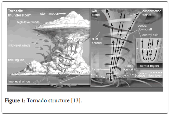
DiscussionEditIn Figure 1 Tornado Structure has been displayed [13]. In Figure 2 displays the snapsjot of video posted on YouTube through social networks in June 6, 2017. In the picture one can see the well-defined shape of a tornado. Image of the supposed tornado in Rosário de Ivaí and Rio Branco do Ivaí, June 6, 2017. In the image one can observe the defined format of a tornado. The Figure 3 shows the damage caused at home by alleged Tornado in Rosario do Ivaí. Figure 1: Tornado structure [13]. Figure 2: Snapshot video posted on YouTube through social networks. June 8, 2017 [2]. Figure 3: Photo of damage caused at home by alleged Tornado in Rosario do Ivaí [3]. The highlighted image of Figure 4, obtained via satellite GOES 13/ NOAA/USA-Infrared Channel+enhancement-06/06/2017-Local time: 06:40-South of Brazil. Source: RAMSDIS Online-Central and South America and the Caribbean, Cooperative Institute for Research in the Atmosphere, Colorado State University, USA, modified by LabClima/ UNIVALI. In the image the formation of two supercells of storms in the central region of the state of Paraná is clear, with temperatures ranging from -50°C-60°C. Figure 4: Image of satellite GOES 13/NOAA/USA-Infrared Channel +enhancement- 6/06/2017-Local time: 06:40-South of Brazil [31]. Figure 5 shows the map of the state of Paraná, with the prominent location of the municipalities of Rio Branco do Ivaí, in lime green color and Rosário do Ivaí, in pink color. Figure 5: Map of the state of Paraná, with the prominent location of the municipalities of Rio Branco do Ivaí, in lime green color and Rosário do Ivaí, in pink color (Adapted). It is verified that according to Figures 6 and 7, the collision of cold fronts originating from the SO of Argentina with hot air masses coming from the NW of Brazil, from the Amazon, moving through Rondônia, Mato Grosso and Mato Grosso do Sul. When they meet, they collide by tapering from SO to OSO, and from NO to ONO, adding both coming from the West, and going east when entering the State of Paraná. When they add up and collide they move with great speed, provoking strong winds and intense rains, in a short period of time. Figure 6: The images were obtained from the REDEMET (Rede de Meteorologia do Comando da Aeronáutica. GT-REDEMET) website for June 6, 2017, from 2:30 p.m. to 8:30 p.m. (UTC) at 30 minute intervals. They are highlighted and indicate the temperature from 45°C-90°C (Adapted) [5]. Figure 7: The images were obtained from the REDEMET (Rede de Meteorologia do Comando da Aeronáutica. GT-REDEMET) website for June 6, 2017, from 2:30 p.m. to 8:30 p.m. (UTC) at 30 minute intervals. The images are in the visible spectral, in black and white. They represent the reflectance factor from zero to 80% (Adapted) [5]. Figures 6 and 7 were obtained through the REDEMET-Meteorology Network of the Aeronautics Command, which aims to integrate meteorological products aimed at civil and military aviation. The images of Figures 6 and 7 were obtained from the REDEMET website for June 6, 2017, from 2:30 p.m. to 8:30 p.m. (UTC) at 30 minute intervals. They are highlighted and indicate the temperature from 45°C-90°C. It is observed the evolution of the storm with the formation of several cores of supercells of storm that advance of west to east, crossing the state of Paraná. Supercell peaks occur in the central region of Paraná, between 18:00 UTC and 19:00 UTC, with two storm supercells and a smaller one in the region of Rio Branco do Ivaí and Rosario de Ivaí. The three core appear well defined in the enhanced image from 18:00 UTC, with temperatures of approximately -70°C, for larger nuclei, and the lowest -90°C, represented in blue and red, respectively. Probably the core of -90°C occurred hail drop. At the same time, the image indicates four supercells. Three in the central region, one in the eastern region, and the other in the states of Paraná, Santa Catarina. This one moves from the south coast of Paraná, north of Santa Catarina and advancing offshore. The larger nucleus grows rapidly, decreasing its temperature, when approaching the region of the mountain range and when reaching the ocean. |
ConclusionEditWith the collected images, published in social networks by residents, citizens of the counties of Rosário de Ivaí, Rio Branco do Ivaí, in the state of Paraná, southern region of Brazil. With the published images of newspapers and blogs on the Internet and with the images obtained in GOES 13 satellites and published in REDEMET-Meteorology Network of the Aeronautics Command. There is strong evidence characterizing the formation of tornadoes in the central region of the Paraná state, in these counties, on June 6, 2017, at 6:00 p.m. UTC and 7:00 p.m. UTC. |
ReferencesEdit
|
